
|
Three Peaks Walks |
| Buy the 3 Peaks CD-Rom/DVD here |


|
|
Three Peaks Walks |
| Buy the 3 Peaks CD-Rom/DVD here |
|
Best gifts for walkers - 35 top presents for hikers under £35 If you are wondering what to buy someone who likes walking, or searching for those inexpensive or personalised gifts for hikers, then look no further. We've put together a selection of practical presents under £35 that any walker or hiker in the UK would like to receive. Read our article: Best gifts for walkers - 35 top presents for hikers under £35 |
Even though walking any of Pen-y-ghent, Whernside or Ingleborough in isolation is satisfying walks in itself, there is a one thing that many people seem to like - a challenge! The Three Peaks of Yorkshire provide that challenge by linking together the three summits in a 25 mile walk, which should only be undertaken by strong walkers. Do not think though that with lots of training you will produce a record time, because each April the Three Peaks route attracts many of the countries best fell runners who have brought the winning time down to around 2½ hours, on albeit a slightly shorter route. Instead of taking the more circuitous route to the summit of Whernside followed on the Three Peaks Walk, they follow the old direct route straight up to the summit.
The walk as described below starts from Horton-In-Ribblesdale and follows an anti-clockwise route first up Pen-y-ghent, then Whernside and finally up Ingleborough, before descending the final few miles back down to Horton-In-Ribblesdale. View accommodation close to the start of this walk from Sykes Holiday Cottages or from Holidaycottages.co.uk.
The walk is described in outline below, with a much more detailed turn by turn route description being included on our Three Peaks Walk eBook. Also included in the eBook is a fly through of the route over the walk area, with pictures of the whole route. These are only a part of what is actually included - check out the eBook for full details.
Do not set out on the route if you are not confident you can walk the 25 miles. Before setting out, please ensure you check the local weather forecast, as conditions can quickly change. Always carry the relevant map for the route which is the Ordnance Survey 1:25,000 map of the area: Explorer OL2 (Yorkshire Dales - Southern & Western Area). Buy this map from Ordnance Survey.
|
What to wear and take on your walk: If you are new to walking and want to know what to wear and take on your walk, or just want to know what to consider when buying your walking clothes and equipment then these articles are for you. We'll also take you through our favourite walking boots, walking jackets, walking trousers, rucksacks, backpacks, water bottles, mapping and safety equipment etc. of 2024. Read our articles: What to wear on a walk and What to take on a walk |
| Parking: | Pay and display car park in Horton in Ribblesdale (grid reference SD 807 725) - small amount of road side and layby parking available, but please park responsibly as Horton does get busy, especially at weekends and bank holidays. |
| Directions: | Google Maps: get directions here / What3words: harmless.outgrown.fake |
| Map: | Ordnance Survey - Explorer OL2 (Yorkshire Dales - Southern & Western Area) Buy this map from Ordnance Survey |
| Nearest town: | Walk starts in Horton in Ribblesdale, nearest larger towns Settle or Ingleton |
| Local accommodation: | View accommodation close to the start of this walk from Sykes Holiday Cottages or from Holidaycottages.co.uk |
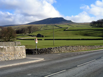
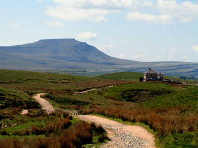
Pen-y-ghent from Horton at the start of the walk
There is a reasonable sized pay and display car park in Horton about one hundred yards from the Pen-y-ghent Café. The walk starts by turning right out of the café (or car park), following the road round by the church and turning left to follow the lane around to Brackenbottom farm. A path turns left off the lane just before the farm and then left again as it starts to climb slowly over a series of stiles, until, over the last one, the path meets up with the Pennine way. Over this stile, the path turns sharp left and heads northwards up the couple of steeper sections to reach the summit of Pen-y-ghent.
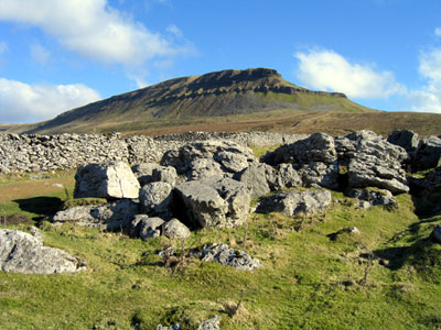
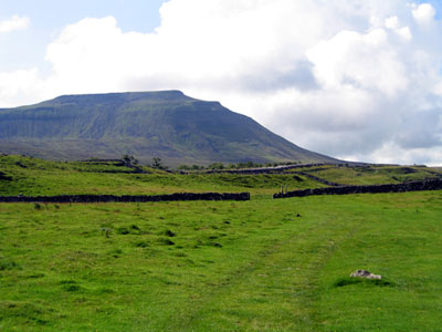
Approaching Pen-y-ghent
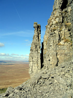
The pinnacle just off the path descending from Pen-y-ghent
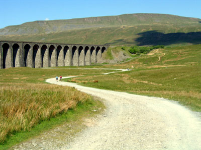
Heading towards Ribblehead Viaduct, Whernside ahead
From the triangulation point, head left over the wall, and continue in a straight line away from it. The path descends steeply at first before swinging to the right and then to the left with a pinnacle ahead, to continue its descent past Hunt Pot and over a couple of stiles to reach the end of Horton Scar Lane. From here the new section of path built in the winter of 2012 is followed over Whitber Hill to join the Pennine Way, which is followed for about a mile, before turning left off it and heading towards High Birkwith. From here, the path passes God's Bridge before heading on to Nether Lodge and by Lodge Hall and then out onto the B6479 Horton to Ribblehead road. This road is followed to the T-junction just before the Ribblehead viaduct.
Looking across towards Ingleborough and back towards the Blea Moor signal box
At the T-junction, the path continues straight on, crossing Batty Green towards the viaduct. The path keeps the viaduct to its left and continues on past the signal box. It then continues along Little Dale by the side of the railway, before crossing it by way of a small aqueduct some three quarters of a mile further on. Once over a stile the path swings left and starts to climb, with views of Force Gill waterfall to the left. After a short, steep climb, a stile is crossed and a path across Grain Ings, before it pulls in by a wall which is followed to the summit of Whernside. The triangulation point on Whernside is just through the far side of the wall.
The path then carries on in the same direction slowly descending at first whilst still keeping by the wall, until when almost level with Bruntscar Farm down below, it heads directly away from the wall towards the farm. The path descends steeply at first, before winding its way across the fell side to reach Bruntscar. A lane is then followed as it meanders its way downhill across the fields before gently climbing up Philpin Lane. This is followed past the farm buildings until it reaches the main B6255 Ingleton to Hawes road. Turn left onto the road, past the Old Hill Inn public house.
Turn right through a few fields and in front of Southerscales Scars, before it starts to slowly climb and wind its way through some wonderful limestone pavements.
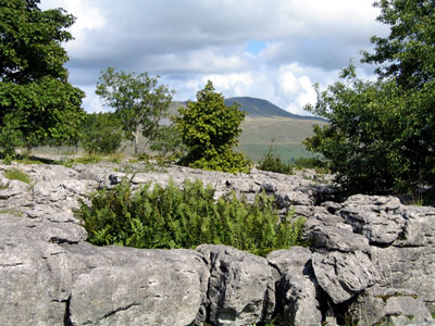
Heading towards Ingleborough
Looking across a limestone pavement on Ingleborough towards Whernside
The path then takes to stone slabs and wooden boards for most of the section over Humphrey Bottom and the Ingleborough Nature Reserve climbing slowly to the bottom of the much steeper climb. Here the path then zigzags steeply up the side of Ingleborough. Once the path flattens it swings around to the right, continues on up some man made steps, before progressing along for the final couple of hundred yards along the flat plateau on top to the weather shelter and triangulation point.
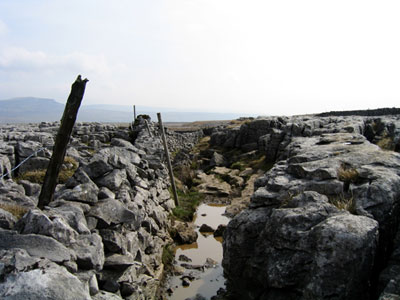
Path through a limestone pavement
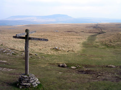
Signpost points the way across Sulber back to Horton
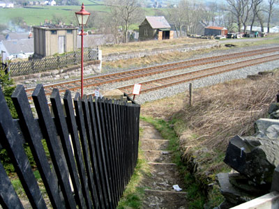
Entering Horton railway station
From here retrace the path up, before branching off to the right to head across Simon Fell Breast. The path gently descends across the fell, passing an old shooting hut before reaching large areas of limestone outcrops. Continue through the limestone by way of Sulber and Sulber Nick, before crossing the final few fields to arrive at Horton railway station, which is on the Settle to Carlisle line. From here the road is followed for the final few yards back into the car park.
Click here for Disclaimer


