Written by: Andrew Forrest
Updated: July 2025
The National Three Peaks Walk (or 'National 3 Peaks Challenge') involves climbing the highest mountain in each of Scotland, England, and Wales - Ben Nevis, Scafell Pike, and Snowdon - usually with long drives in between them.
While the National Three Peaks Walk involves climbing Ben Nevis, Scafell Pike, and Snowdon, the 'challenge' part is completing all three within 24 hours, turning it into a combined endurance hike and road-trip adventure.
Successfully conquering all three peaks requires hiking approximately 23 miles (37 km) with about 3,100 m of total ascent, as well as driving around 450 miles in between. This challenging feat tests your fitness, planning, and resilience.
Each of the three mountains has its own character and challenges:
The challenge lies not only in hiking, but also in driving. Typically, you start at one mountain, then drive to the next, and then to the
following one, often crossing the country overnight.
There is no specific required route or order, but a common approach is north to south: start with Ben Nevis in Scotland, then move on to Scafell Pike in England, and finish with Snowdon in Wales. This way, the longest climb is tackled first, and the 'easiest' peak comes last when you're most tired. However, the logistics can be organised in any order that suits your team.

In summary, the National Three Peaks involve significant hiking and driving - it's as much a test of endurance and organisation as it is of
hiking ability. Below, we'll explore two ways to approach the Three Peaks, how to prepare, the importance of a support crew, detailed routes
for each mountain (including start and end points), and crucial safety considerations such as
weather,
navigation, and terrain hazards.
As we have done with the Yorkshire Three Peaks walk on this website, we will continue to expand this National Three Peaks walk section. Later in 2025, we will include full videos of all the routes, allowing you to see what to expect and familiarise yourself with the route before you start.
The traditional goal is to climb all three peaks within 24 hours (including travel time). This is a gruelling endurance challenge - often involving approximately 12.5 hours of total hill walking and around 11.5 hours of driving.
Your own schedule will depend on how quickly you can walk, climb and descend, but a typical schedule might allocate around 5 hours to ascend and descend Ben Nevis, about 5.5 hours driving to Scafell, approximately 4 hours for Scafell Pike, around 6 hours driving to Snowdon, and roughly 3.5 hours for Snowdon.
Many challengers start in the late afternoon to minimise night hiking: for example, starting Ben Nevis at around 5:00 pm, finishing by 10:00 pm, climbing Scafell Pike overnight around dawn, and ascending Snowdon the following afternoon. Succeeding within 24 hours necessitates swift movement, efficient transitions, and a bit of luck with traffic and weather.
It's a serious test - in fact, many people fail on their first attempt, often due to underestimated fitness levels or delays. The 24-hour version should be regarded as an extreme challenge; pushing against the clock can induce stress and increase risk, so always prioritise safety over an arbitrary time limit.
Not everyone wants to or should rush through in one day. A popular alternative is to spread the Three Peaks over a longer period - for example, one peak per day over a long weekend, or one peak on each of three separate weekends.

There's no rule that you must do them back-to-back. Taking them at a relaxed pace allows you to enjoy the experience and scenery at
each mountain and recover fully between climbs.
Some choose to do it in three days (Ben Nevis on Day 1, drive and Scafell Pike on Day 2, then Snowdon on Day 3), or even over three consecutive weekends. Others simply aim to complete all three in the same year or over time, treating it as a personal goal rather than a non-stop race.
The benefit of a slower approach is far less time pressure, no sleep deprivation, and you can explore local areas after each climb. It's still an achievement to climb all three peaks, whether it takes 24 hours or 24 weeks! In fact, many charity events offer 'Three Peaks in Three Days' challenges for a more moderate experience. By tackling each mountain separately, you also avoid the bulk of overnight driving and reduce the risk of mistakes due to fatigue.
The bottom line is that if the 24-hour dash feels too intense or unsafe, consider a multi-day plan - you'll still earn bragging rights for conquering the Three Peaks, while probably having more fun and fewer blisters.
Personally, as much as I enjoy challenges, I have completed each of the National Three Peaks several times, and my most memorable experiences have come from doing them while spending a week in that area. If you are there for a few days, you can hopefully pick a dry day to enjoy the walk and the views, as well as explore many other walks that the area has to offer. The region around Glencoe, just south of Ben Nevis, is one of my favourite places to walk.
The information provided here is intended for general educational purposes only and should not be regarded as medical advice or a substitute for professional healthcare. If you are experiencing a medical emergency or serious symptoms, seek immediate assistance from a qualified medical professional or contact emergency services. Always consult your GP or a healthcare provider for personalised medical guidance and treatment.
Before beginning any exercise programme, especially if you are new to exercise, returning after a break, or have any existing health concerns, you should consult with your GP or a qualified healthcare provider. Always listen to your body and stop immediately if you feel discomfort, dizziness, or pain.
Tackling the Three Peaks, especially within 24 hours, requires excellent fitness. You don't have to be a marathon runner, but you should be capable of hiking uphill for hours with minimal rest.
As part of your planning, you need to determine the speed at which you must complete each mountain. Then, during your practice walks, aim to walk faster than that, as you will tire as the day progresses. If, during your practice walks with similar climbing, you are not achieving the speed necessary to complete the Three Peaks in 24 hours, I would suggest you undertake them on a more leisurely timescale.
Prepare for the equivalent of undertaking three significant mountain hikes in close succession. It is advisable to train for a few months in advance, concentrating on cardiovascular endurance and leg strength. Regular hiking on inclines is one of the most effective forms of preparation - aim to undertake long hikes across uneven terrain, progressively increasing your distance and elevation gain.

Incorporate cardio workouts (running, cycling, stair-climbing) to build stamina, along with leg and core strength exercises (squats, lunges,
etc.) for stability. If you plan to undertake the 24-hour challenge, also practise functioning with limited sleep and consecutive days of
hiking - mental resilience is crucial when you're tired at 4 am on a dark mountain. Remember that even 'reasonably fit' individuals find this
challenge tough; do not underestimate it, and make sure to invest time in training. It's far better to start the challenge slightly over-prepared
than to struggle or have to quit due to inadequate fitness.
Proper equipment will help keep you safe and comfortable in the mountains. Sturdy, broken-in hiking boots with good ankle support are essential for tackling rocky and uneven trails. Parts of the route on the National Three Peaks are considerably rockier and more uneven than the Yorkshire Three Peaks walk.

Hiking kit for the National Three Peaks walk
Wearing weather-appropriate clothing in layers is essential, as conditions can shift from warm at the base to freezing rain on the summit. Choose moisture-wicking base layers, insulating mid-layers like fleece or down, and ensure you have a waterproof jacket and over-trousers.
Always pack a warm hat and gloves, even in summer, since it can be very cold and windy on the peaks. A headtorch (headlamp) with spare batteries is necessary, as you might find yourself hiking in the dark either early in the morning or at night.
Other important gear includes a comfortable backpack for carrying water, snacks, and equipment, a map and compass or GPS for each mountain (along with the skills to use them), a basic first aid kit (don't forget blister plasters!), and emergency items such as a foil blanket or lightweight bivvy bag, just in case. Trekking poles can be beneficial for reducing the impact on your knees during long descents, but if you use them, ensure you have practised with them first.
Additionally, bring plenty of high-energy food and water - at least 2-3 litres of water per mountain (or a means to treat/refill water) and snacks such as nuts, energy bars, and sandwiches to maintain your calorie intake. Staying fuelled and hydrated will significantly enhance your endurance and focus during the challenge. Even if you don't feel hungry or thirsty, continue to sip and snack regularly to help prevent fatigue. A hydration bladder is useful for sipping as you go and keeping your hands free.
A good idea is to have plenty of food and drink in the car, so you can refuel while on the driving stages. Keep some dry spare gear in your vehicle so that if you get wet, you can change out of wet gear between mountains.
For a comprehensive list of items to wear and take on your walk, refer to our Yorkshire Three Peaks Walk kit list.
If you plan to undertake the National Three Peaks challenge within 24 hours, careful planning is crucial for a smooth attempt.
First, consider the time of year - late spring to early summer (May to July) is generally best, offering long daylight hours, milder weather, and (in June) fewer crowds and midges. Avoid winter unless you are an experienced mountaineer, as October to March brings short days, frequent snow and ice on Ben Nevis, and hazardous conditions that require winter gear and the necessary skills to use it. If you can plan for a midweek attempt, the area around each of the mountains will be quieter, especially around Snowdon, which can become very busy at weekends.

A busy Snowdon summit, with many people having taken the train from Llanberis to the top
Next, plan your itinerary and timings: if aiming for 24 hours, map out a schedule for when to start each climb and how long to drive between them - be realistic about your team's pace. Always plan around the slowest member of your party.

Aim to maximise daylight; for example, many begin Ben Nevis in the late afternoon, meaning only part of Scafell Pike is in the dark, while
Snowdon can be tackled in daylight. Build in a bit of a cushion for unexpected delays (traffic jams, slower hiking, etc.).
Transportation is a major element - decide how you will travel between peaks. Most people use a car or minibus. If you are self-driving, assign a designated driver (or two) who will take the wheel while others rest. Ideally, they will be non-walking drivers who accompany you for driving purposes only.
Ensure your vehicle is reliable and that fuel stops are planned. It helps to familiarise yourself with the driving route beforehand - for instance, it's roughly 5 to 6 hours from Fort William (Ben Nevis) to Wasdale (Scafell Pike), and about 5 to 6 hours from Wasdale to Snowdonia (Snowdon).
Also, research the parking situation at each mountain: Ben Nevis has a Visitor Centre car park with a small fee, Wasdale has limited National Trust parking, and Snowdon's Pen-y-Pass requires pre-booking in advance (with alternatives like park-and-ride shuttles). If you have dedicated drivers, they can drop you and park elsewhere until they are needed to pick you up.
Don't forget to check weather forecasts for each mountain right up to the last minute (the UK Met Office and Mountain Weather Information Service provide mountain-specific forecasts). If the forecast indicates dangerous conditions (storm, heavy rain, high winds), be prepared to adjust your plan or postpone - safety should take precedence over schedule.
Finally, if you are new to mountain navigation, consider hiring a guide or ensuring that at least one experienced navigator is in your team. Getting lost can waste valuable time or worse, so plan your routes and consider loading GPS tracks as a backup (but still carry a map and compass - do not rely solely on phone navigation in the mountains, as signal and battery can fail). In low cloud or mist, or when snow is on the ground, the summit of Ben Nevis can be perilous if you are not on the path.
Good planning also includes having a contingency plan: know what you will do if someone in the group has to stop (e.g., not everyone may summit every peak - and that's perfectly alright). Communicate your plans with someone not on the trip and ensure emergency numbers (Mountain Rescue via 999) are easily accessible, just in case.
With thorough preparation - fitness, gear, and logistics - you'll equip yourself for the highest chance of success and a pleasurable experience.
One of the biggest factors in a successful 24-hour Three Peaks Challenge is having a Support Crew or dedicated drivers. The challenge involves over 10 hours of driving alongside the hiking, often overnight. Driving on narrow, dark roads (e.g., into Wasdale or through rural Wales) while extremely fatigued is dangerous - I would recommend that you do not attempt to climb and do all the driving yourself.
Instead, organise for one or two drivers who can share the load and remain rested. A support driver will handle navigation on the roads, manage the traffic, and, crucially, allow the hikers to sleep or recuperate between mountains. Even a short nap between peaks can significantly enhance your safety and performance on the next climb.

Beyond driving, a good Support Crew can assist with logistics in many ways. They might help prepare meals or snacks so they're ready as
soon as you come off a mountain, saving you time. They can ensure that the vehicle is refuelled and stocked with water and supplies while
you're hiking.
If you have a larger team, some members can take turns resting and driving, but ensure that any driver is fresh enough to stay alert. The Support Crew also serves as your cheer squad and safety net: monitoring the team's wellbeing, encouraging hydration and proper eating, and being prepared with dry clothes or a first aid kit if needed when you return to the van. If someone decides to withdraw from a climb due to exhaustion or injury, the support driver can look after them or take them to a safe location. Essentially, the hikers concentrate on hiking while the Support Crew manages everything else.
During the 24-hour challenge, time is tight, but never be tempted to make up time by reckless driving. The common advice is to 'make up time on the mountains, not on the roads' - i.e., if you're behind schedule, perhaps you can hike a bit faster or shorten breaks, but do not speed or cut corners in transit. Road accidents or getting pulled over will not only end the challenge, but can end lives. A support driver who is not fatigued from climbing will be far better able to drive safely within speed limits and handle the stress of night driving.
Also, consider the route and traffic: if possible, plan your driving legs to avoid known congestion times (for example, Glasgow traffic on a weekday evening when heading south from Ben Nevis, or tourist traffic near Snowdonia on a summer weekend). Smart timing and a bit of luck can save hours of highway standstill. Some teams choose to start very early or late to miss rush hour.
If you don't have a willing driver, consider a guided event where professionals manage transport, or opt for a multi-day itinerary to avoid driving while fatigued. However, if you do have friends or teammates acting as crew, treat them like gold - you literally couldn't do it without them. Ensure they receive thanks (and perhaps a nice treat) for their significant contribution to your Three Peaks success.
Each of the Three Peaks has multiple trails, but here we'll focus on the most common routes used for the challenge and general hiking, including starting points and what to expect on the way up and down. We'll also note some navigation considerations and recommended start/end logistics for each.
Ben Nevis is located in the West Highlands of Scotland, near the town of Fort William. It stands at 1345 m (4413 ft), making it the tallest mountain in the UK. Unlike the other two peaks, the path up Ben Nevis begins almost at sea level, requiring you to ascend the mountain's full height from base to summit. This results in a lengthy climb - it is typically the longest single hike of the Three Peaks.

Mick, Dominic his son and Alfie by the trig point on Ben Nevis
Most people start from the Glen Nevis side of the mountain. There is a visitor centre and youth hostel at Glen Nevis, which serve as common starting points (both paths merge early on). The visitor centre car park (postcode PH33 6ST) is conveniently located, although it can become full, and parking incurs a small fee.
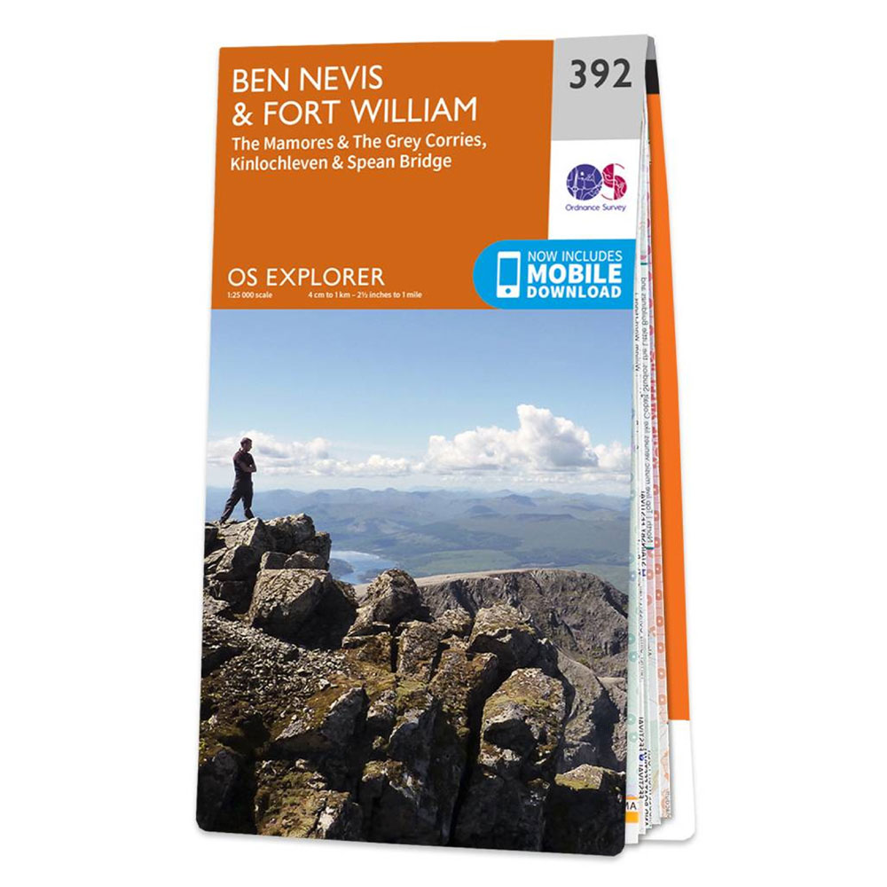
The Ordnance Survey OS Explorer map 392 (Ben Nevis and Fort William) shows the full National Three Peaks path up Ben Nevis.
 |
 |
 |
|
The usual route is via the Mountain Track, often called the 'Pony Track' or 'Tourist Path'. Despite the 'tourist' nickname, it remains a strenuous 10.5-mile round trip (about 17 km), with an ascent of approximately 1350 m.
The path is well-trodden and partially maintained with stone steps and clear zig-zags. From Glen Nevis, you'll cross a bridge and begin a steady climb. Early on, a spur from the youth hostel joins the main trail. After a couple of hours, you arrive at a small lochan on your left (Lochan Meall an t-Suidhe, a.k.a. the 'Halfway Lochan'), which is about halfway in distance, but unfortunately, you haven't done half the climbing yet! This section is relatively flat - a good spot to catch your breath and enjoy the views of the valley behind. Beyond the loch, the real work begins: the trail zig-zags up the steep upper slopes of Ben Nevis in a series of switchbacks. The ground becomes increasingly rocky and barren
As you approach the summit plateau, you may encounter snow. Ben Nevis often has snow patches lingering well into summer. It's common to have snow covering parts of the path until late May or even June. The summit area is wide and stony. Near the top, a line of large cairns (stone piles) marks the final approach to the summit trig point. At the very top, you'll find the ruins of an old observatory and a modern emergency shelter. If the weather is clear, the views are immense, stretching across the Highlands - but note that Ben Nevis is often shrouded in cloud (the summit is famously foggy or white-out for much of the year). Take your summit photos by the trig point and congratulate yourself - one peak down!
Ben Nevis' Mountain Track is straightforward in good visibility - essentially one path up and down. However, in poor visibility conditions, such as fog, low cloud or white-outs, the summit plateau can be deceptively dangerous. Sheer cliffs (the North Face) drop sharply, not far north of the summit. Sadly, over the years, many accidents have occurred and people have died when walkers lost the path and wandered towards steep drop-offs.
If you summit in fog, you must be able to navigate by compass to descend safely. There is a recommended compass bearing to follow from the summit to avoid the cliffs. It's wise to study this in advance or have a GPS track, because you cannot rely on seeing the cairns - in thick mist, you might only see 10 m ahead. Always stick to the main trail on descent; do not be tempted by any shortcuts across switchbacks, as people who stray have ended up in the wrong gully.
The Ben Nevis weather can be dramatically different from bottom to top - sunny and mild at the base, but near freezing with gale-force winds at the summit. It's not unusual for the summit temperature to be 10°C colder than Fort William below, with wind chill making it feel even colder. Rain or mist can soak you, and the rocky path can become slippery.
Be prepared with waterproofs and warm layers, and turn back if conditions become unsafe (the mountain will always be there for another day). If you're doing the 24-hour challenge, you'll likely climb Ben Nevis in late afternoon or evening, possibly catching sunset on the way down. Make sure to have headtorches ready if there's any chance of descending in the dark. Overall, Ben Nevis is a long, demanding hike - but take it steady, enjoy the scenery on the way, and remember this is the biggest mountain you'll tackle on the challenge. Completing it (safely) is a huge confidence boost for the rest of the journey.
Southwest Highlands mountain weather on Met OfficeMany teams start Ben Nevis late in the day (e.g., 5 pm) to ensure the later peaks fit into a 24-hour window. It generally takes 5 to 7 hours for an average group to complete the round trip - quicker if you're fit and moving swiftly, but plan for the longer duration if you aim to pace yourself. Finishing Ben Nevis around sunset is quite common.
After returning to the Glen Nevis base, you will set off on the drive to England. The journey from Fort William to Wasdale (Scafell Pike) typically takes around 5.5 to 6 hours by road, assuming good traffic conditions. Ensure that your driver hasn't hiked or is well-rested; this is the time for hikers to eat, rehydrate, and, if possible, try to sleep in the vehicle.
Scafell Pike is situated in the stunning Lake District National Park in Cumbria. Standing at 978 m (3,209 ft), it is the highest point in England. While it is considerably lower than Ben Nevis, don't underestimate it - Scafell Pike's terrain is rocky and rugged, and it can be very challenging, especially when tired. One unique aspect of the Three Peaks Challenge is that Scafell Pike is often climbed at night (as part of the 24-hour schedule) or very early in the morning, which adds to the difficulty. The mountain boasts several routes, but the two most common approaches are from Wasdale Head and Seathwaite (Borrowdale).
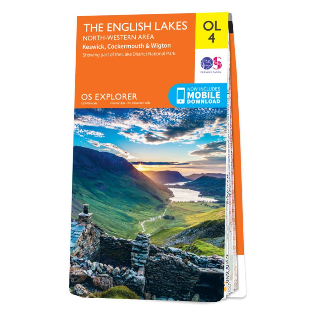
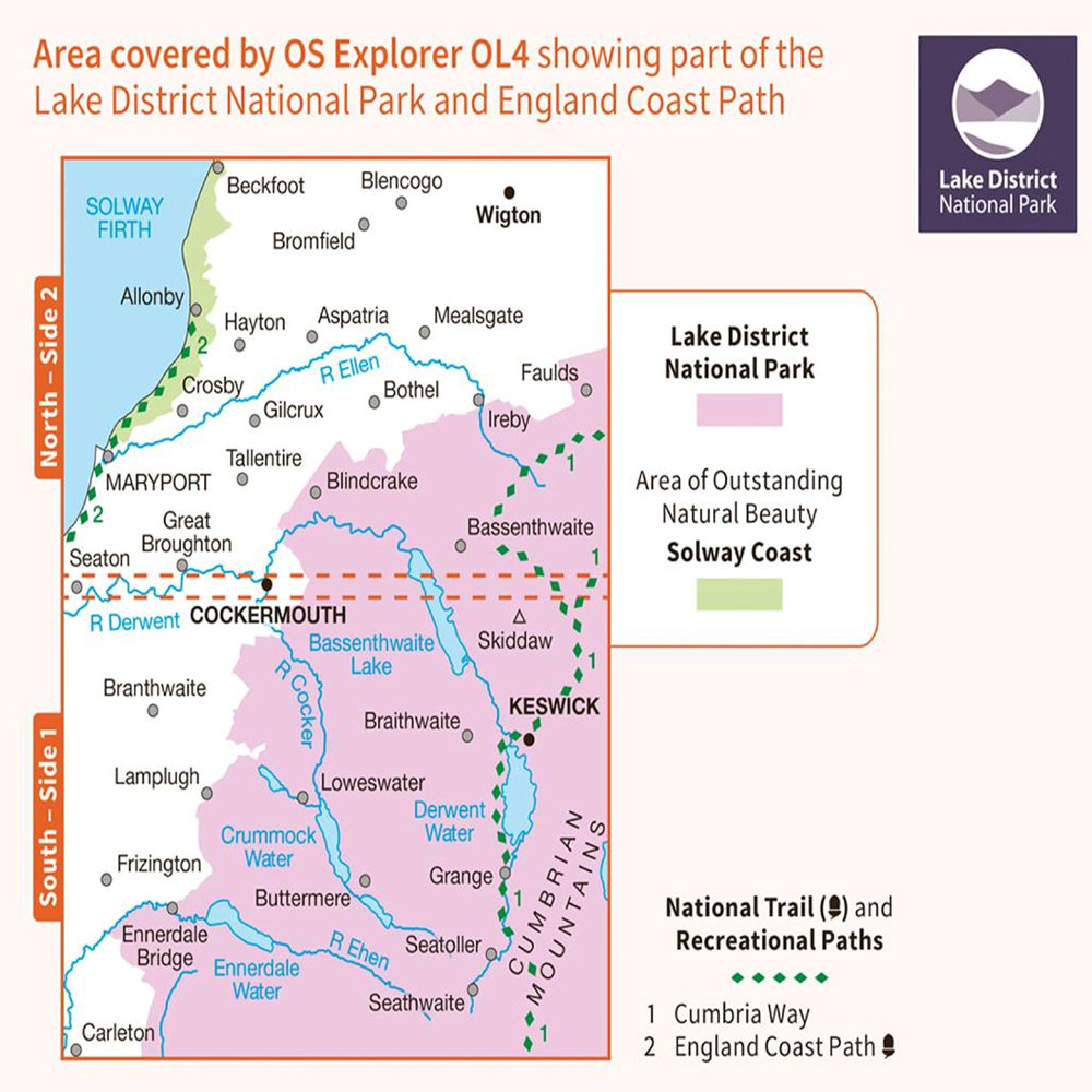
The English Lakes North Western Area - OL4 Map
The Ordnance Survey OL4 map shows the start of the Seatoller route to Scafell Pike; the remainder of the route is on OL6.
|
|
|
|
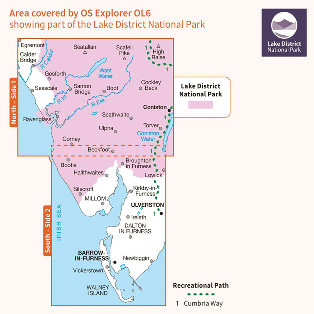
The English Lakes South Western Area - OL6 Map
The Ordnance Survey OL6 map shows the remainder of the Seatoller route to Scafell Pike and the whole of the National Three Peaks Wasdale route to Scafell Pike.
|
|
|
|
This is the shortest and most direct route up Scafell Pike, favoured during the 24-hour challenge for speed. The starting point is Wasdale Head, near the shore of Wast Water (England's deepest lake). The drive to Wasdale takes you through a remote valley; the main car park is the Lake Head car park by the Wasdale National Trust campsite (grid ref NY 182 074). Walkers are encouraged to use this official car park to minimise the impact on the tiny village.
This route is approximately 6 miles (9.6 km) round trip with an ascent of about 989 m - short but steep. Starting from the car park, the trail crosses a stream (Lingmell Gill) and ascends through brown bracken slopes. You'll pass a feature named Brown Tongue and then the Hollow Stones area, which features rocky steps and boulders leading to the upper part of the mountain. Eventually, the path from Wasdale joins others near a plateau area known as Lingmell Col. From there, a final steep climb over jumbled rocks takes you to the summit cairn of Scafell Pike.
The top is a boulder field - a jumble of rocks that can make the last section a scramble. On a clear day, the view from Scafell Pike is stunning, offering a panoramic vista of other Lakeland fells and even the sea. However, you may often find yourself up there in darkness or cloud, so it might simply appear as a pile of rocks in the fog for you! After reaching the summit, you retrace your steps back to Wasdale. The descent on weary legs is punishing - those rocky steps can be jarring on the knees. Take care not to lose the main path among the stones on your way down, especially if it's dark.
This is a longer yet scenic way up from the Borrowdale valley. Starting at Seathwaite farm, the route is approximately 9-10 miles round trip with around 996 m of ascent. It's popular with hikers who are not under strict time constraints, or for Three Peaks attempts carried out over several days. Parking at Seathwaite is very limited and often congested, so many park at alternatives like Seatoller and walk in.
The trail begins by passing through the farm and up to Stockley Bridge, then ascends to Styhead Tarn via the Sty Head path. From Sty Head, one follows the renowned Corridor Route, an undulating path that traverses the western flank of Scafell Pike. This path offers dramatic views and passes under Great End and Broad Crag. It eventually climbs up to Lingmell Col, where it meets the route from Wasdale, and from there the final ascent to the summit is made.
The Corridor Route features a couple of minor rock step scrambles and can present a navigational challenge in mist, but it's considered one of the best Lakeland routes. Upon descending, one typically returns the same way (though some opt for a loop via Esk Hause). Due to its length, the Seathwaite route is generally not used in a 24-hour attempt - it simply takes too long. However, if you're tackling Scafell Pike on a separate trip or with more time, it's a rewarding hike.
Scafell Pike is known for causing navigational issues. In fact, the local mountain rescue reports that most Three Peaks call-outs are for people lost on Scafell Pike, as it is frequently tackled at night and the summit terrain can be perplexing. If you are climbing in the dark (which is likely if you start around 3-4 am, as many schedules do), take extra care. A map and compass (and the ability to use them) are essential - do not rely solely on following other groups or on a phone app, as there are many interwoven paths, and the signal is poor.
One notorious hazard is Piers Gill - a deep gill (stream ravine) situated near one of the descent paths. Some lost hikers mistakenly veer towards Piers Gill, believing it to be the way down, which can lead to treacherous ground. Stick to the main path you ascended, or if using an alternative descent, ensure you are aware of the correct turn-offs. If you realise you are disoriented, it may be best to wait for dawn rather than inadvertently wander off-track - as Wasdale Mountain Rescue Team advises, 'being lost is not an immediate emergency; sometimes the safest option is to bivvy until daylight'.
Always carry a headtorch (plus a spare) and a whistle to signal for help if needed. If you are well prepared, Scafell Pike can be navigated safely at night, but fatigue can make it more challenging - this is where having an experienced navigator or hiring a local guide can prove invaluable. Always ensure you have practised walking at night.
Expect rugged terrain on Scafell Pike. Much of the route (especially from Hollow Stones upward or on the Corridor Route) is on rocks and scree. Use sturdy footwear and watch your footing - a twisted ankle here would likely end your challenge. The summit boulder field requires stepping from rock to rock, so take it slowly in poor visibility or wet conditions.
Many hikers believe Scafell Pike is the hardest on the legs despite being the shortest, due to its relentless, steep, rocky incline. On the descent, your thighs will burn and your knees will ache from taking large steps down. Hiking poles can help absorb impact. If it's dark, cold, or raining, ensure everyone stays together and that no one is left struggling at the back unseen - it's easy to get separated on a dark mountain, so conduct headcounts and use your lights.
A fit group might ascend and descend Scafell Pike from Wasdale in about four hours, but a more typical time, especially if tired, is five to six hours. If you started around 3:30 to 4:00 am, you could be back by 8:00 to 9:00 am. Daylight will likely arrive during your descent in the summer months, which is a relief.
Once back at your vehicle in Wasdale, it's time for the longest drive of the challenge - roughly five and a half to six and a half hours to Snowdon in North Wales. This drive can feel brutal after being up all night. Support drivers should swap out if they are tired. Use this drive to have a proper breakfast, rehydrate, and yes, try to catch some sleep (even an hour's nap will help before Snowdon).
If you're doing the peaks more leisurely, you might climb Scafell Pike in the daytime, which is obviously easier and more enjoyable - and perhaps stay overnight nearby before heading to Wales the next day.
Lake District mountain weather on Met OfficeSnowdon - known in Welsh as Yr Wyddfa - is located in Snowdonia National Park (Eryri) in North Wales. Standing at a height of 1085 m (3,560 ft), it is the highest mountain in Wales. Snowdon is renowned for being one of the busiest mountains in the UK, attracting hikers of all abilities.

The café on the top of Snowdon
It features a mountain railway that transports tourists close to the summit, along with a café at the top - check opening times if you are relying on it.

The Snowdon summit sign on the side of the café
Snowdon has many routes to the summit, but the 'main three' often referenced are: the Pyg Track, Miners' Track, and Llanberis Path.

Looking north-west from the Rhyd Ddu path on Snowdon with Anglesey in the distance
Additionally, there are other paths such as the Ranger Path, Rhyd Ddu Path, and the more technical Crib Goch Ridge route, although these are less commonly used for the Three Peaks due to either their starting locations or levels of difficulty.

Looking back down the Cambrian Way path on Snowdon
The Ordnance Survey OS OL17 shows the Llanberis path, the Pyg Path and the Miner’s Path up to Snowdon.
|
|
|
|
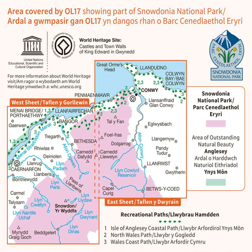
The most popular starting point for Snowdon is Pen-y-Pass (on the A4086 pass road). Both the Pyg and Miners' tracks begin here. Pen-y-Pass has a small parking lot, which I believe must be pre-booked. Because it's often full, many challengers either pre-book in advance or use nearby park-and-ride lots (at Nant Peris or further down at Pen-y-Gwryd, with shuttle buses running frequently). If you have a support car, they could drop you off and park elsewhere.
Alternatively, the Llanberis Path starts in Llanberis town. Llanberis has a lot more parking available. If you have a support driver, one strategy some use is to have them drop the hikers at Pen-y-Pass to start on the Pyg or Miners, then drive around and meet the team in Llanberis after they descend that way. The routes can be combined in this way (ascend one way, descend another) if planned.

The brass mounting plate on Snowdon's trig point
This is a classic Snowdon route from Pen-y-Pass. It is shorter and steeper than Llanberis. The Pyg Track begins just behind the Pen-y-Pass car park, marked by a signpost. It climbs steadily and is rocky underfoot from the very start. The origin of the name 'Pyg' is debated - some say it's from the old Pen-y-Gwryd (PyG) hotel, while others suggest it was used to carry 'pyg' (tar) - but regardless, it's a well-defined path.
The distance is approximately 7 miles (11 km) round trip, with around 730 m of ascent. Early on, you are treated to grand views of the glacial valley and the lakes (Llyn Llydaw and Glaslyn) below. The Pyg Track runs high above the Miners' Track (which passes by the lakes) and eventually, the two converge.
There's a notably large upright stone waymarker where the Pyg and Miners paths meet, about half an hour from the summit. Beyond this junction, a steep final zig-zag path ascends to Snowdon's summit ridge. When you reach the ridge, you connect with the Llanberis Path for the last few minutes to the actual summit cairn (trig pillar).
At the top, there's a stone trig point, and if it's open, the Hafod Eryri summit café is just a few steps away (though many Three Peakers arrive outside its operating hours). The Pyg Track is often chosen for ascent as it starts higher (Pen-y-Pass is at approximately 360 m elevation, giving you a head start) and arguably offers the best views.
Also starting at Pen-y-Pass, the Miners' Track begins on the opposite side of the car park from the Pyg. Initially, it is a wide, well-maintained path, historically built to serve the old mines in the cwm (hence the name). This path is deceptively easy at first: it's nearly flat as it winds around the sparkling lakes Llyn Teyrn, then Llyn Llydaw via a causeway, and on to Glaslyn at the base of Snowdon.
You'll enjoy a gentle walk for a few miles surrounded by stunning scenery. However, after Glaslyn, the easy path comes to an end and the Miners' Track steepens abruptly, climbing to meet the Pyg Track near the large stone marker mentioned earlier. That climb is a challenging, steep hike (almost a scramble in places) that gains significant height quickly.

Looking east from Snowdon's summit, with the Miner's Path visible heading over the causeway on the left-hand side of the Llyn Llydaw reservoir down below
Many who ascend the Pyg Track and descend the Miners Track find the descent on this section tough on their knees. For the Three Peaks, a common strategy is to ascend via Pyg and descend via Miners, creating a bit of a loop - this allows you to experience both trails and is often quicker for the ascent. I find that the steeper parts of Pyg are easier to manage going up than the steep section of Miners. The Miners Track's up-and-down distance is about 8 miles (13 km), slightly longer than Pyg, but if you only descend it, it will feel quick coming down to Pen-y-Pass.
This is the easiest gradient route, often described as the 'tourist path' of Snowdon (since it's wide and follows the railway for part of the way). It starts in Llanberis village, near the base station of the Snowdon Mountain Railway. The Llanberis Path is approximately 9 miles (14.5 km) round-trip, with an ascent of about 975 m (since Llanberis is near sea level).

The Llanberis path as it starts to follow the train track downhill
It's a steady slog up a long slope, but it's never very steep until the final stretch. Many organised Three Peaks challenges actually descend via the Llanberis Path - for instance, some guided groups ascend the Pyg and descend the Llanberis. This is because Pen-y-Pass is at a higher altitude (which is good for ascent), and the Llanberis Path is easier on tired legs for descent (and has ample parking/bus options for pickup).

Looking across at the Llanberis path and train track
If you choose to do the Llanberis up and down, it's straightforward - just a longer walk.

The train track as it approaches the café on the summit of Snowdon
The path is essentially a road for quite some distance, and you may even see the Snowdon train chugging alongside. For challengers, however, starting from Llanberis would add extra ascent (as Pen-y-Pass gives you a 300 m height advantage), so most stick to the Pen-y-Pass routes for speed.
By the time you reach Snowdon, you may feel exhausted, but don't let your guard down. The weather on Snowdon can be as unpredictable as on the other peaks - you might face rain or dense cloud that obscures the path. Typically, the trails (Pyg, Miners, Llanberis) are well-defined and signposted; in daylight, it's quite difficult to get lost if you remain on the main track.
However, in fog, even the broad Llanberis path can seem to disappear into grey, and on Pyg/Miners, one could mistakenly head toward the Crib Goch route, which splits off near the start of Pyg - avoid that unless you intend a grade one scramble! Fortunately, Snowdon is often is done in the daytime for 24-hour challengers (aiming to start Snowdon late morning or early afternoon).
Still, be prepared with your map or GPS, as fatigue can cloud decision-making. One advantage is that Snowdon is the only peak with a summit building - Hafod Eryri, which houses a café and visitor centre (and a train station) - offering shelter and hot drinks during most summer daylight.

Looking up towards the summit of Snowdon from the Snowdon Ranger path
However, if you arrive very early or late, it will likely be closed. Keep in mind that if it's open, you will encounter many tourists; you might suddenly transition from quiet trails to a crowd at the top. The last three times I have summited Snowdon, I have been in a long queue of people waiting to reach the summit trig point.

The queue up to the trig point on the top of Snowdon
On your descent, if heading to Llanberis, simply follow the obvious path down, mostly by the railway. If returning to Pen-y-Pass via Miners, remember to take the fork at the large marker stone towards Glaslyn (don't accidentally continue on Pyg toward Crib Goch).
Eryri / Snowdonia mountain weather on Met OfficeBy objective measures, Snowdon is often regarded as the 'easiest' of the three peaks - the paths are well maintained, navigation is easier, and the vertical climb is less daunting (if starting high). That said, context is everything: tackling Snowdon last, when you're running on fumes, can make even the Llanberis path feel like a mountain of misery. Be mentally prepared for one more ascent.
The good news is that many challengers find a second wind knowing it's the final push. Take it one step at a time. Typically, Snowdon may take 3.5-5 hours for a round trip with a tired group. For instance, you might start around 1:00 or 2:00 pm and return by early evening if all goes well. Reaching the summit of Snowdon is an incredible moment - you've conquered all three! Make sure to capture a photo with your team and the trig point.
If you began with Ben Nevis in Scotland and end on Snowdon in Wales, you've essentially traversed three countries - an epic journey. Many people finish at Snowdon's base (often Llanberis) and celebrate there. There are pubs and cafés in Llanberis where successful teams toast their achievement (maybe with a well-earned pint and a hearty meal).
The full challenge tradition involves starting and finishing at sea level. Many participants begin by touching the water at Loch Linnhe in Fort William, near the main ferry terminal, before the short drive to Glen Nevis. After summiting and descending from Snowdon, you then drive to Caernarfon Castle and touch the water again at the side of the castle car park.
If you've done it in 24 hours, congratulations - that's a massive accomplishment! If not, but you completed the trio safely, that is equally worthy of celebration. Remember, not everyone chooses to or can finish in a day; doing it over a few days or weekends or even months still means you climbed the highest peaks in each country, which is something to be very proud of.
The National Three Peaks may seem straightforward - just walking up three hills - but it can be fraught with challenges that should not be underestimated. A friendly, adventurous spirit is certainly beneficial, but it's also important to approach this with caution and respect for the three exposed mountains. Here, we outline some key dangers and how to mitigate them:
British mountain weather is famously unpredictable. You can experience sunshine in the valley and a blizzard on the summit - on the same day. The higher you go, the colder and windier it tends to get (roughly 1°C drop per 100 m gained). Rain and fog can roll in quickly.
Ben Nevis's summit is often in cloud, and temperatures at the top can be near freezing with strong winds, even if it's mild below. Snow or sleet can occur on Ben Nevis outside of summer months, and lingering snowfields can hide the trail. Scafell Pike and Snowdon also experience high winds and heavy rain on a regular basis. Always check the mountain forecasts a day or two before and the morning of your climbs.
If severe weather is predicted (e.g., snow, ice, gale-force winds, torrential rain, lightning), consider postponing - it's not worth risking your life for a schedule. During the challenge, carry gear for all weather (pack those waterproofs and an extra layer, even if it looks clear) and be prepared to adapt.
For example, if you encounter thick fog, you may need to slow down and use compass/GPS navigation to stay on track. Do not continue to a summit in extreme weather just to tick it off; turning around can be the smart and safe call if things get out of hand. The mountains will still be there to try again.
Navigational error is a leading cause of incidents on the Three Peaks. It's easy to get lost, especially at night or in poor visibility. Each mountain has tricky sections: Ben Nevis's plateau needs precise bearings to avoid cliffs; Scafell Pike's summit area is a maze of rocks where many have taken wrong turns (particularly in darkness); Snowdon has multiple paths and a notorious ridge (Crib Goch) that you don't want to accidentally wander onto.
Good navigation is essential - carry maps for all three areas and know how to read them. Use a compass to verify your direction if unsure; don't just follow the person in front (they might be lost!). At night, everything becomes more challenging - so have strong head torches and spare batteries, and stick close together. Hiking at night with a head torch is far more difficult than people realise - the only thing illuminated is the immediate path ahead of you. If your schedule indicates that you will be doing some night hiking, practise some in advance. A full moon with little cloud cover also helps.
If you're not confident navigating, consider hiring a mountain guide or joining an organised event with leaders. They not only keep you on the right path but also set a safe pace. If you're going self-guided, practice using your compass or GPS in daylight beforehand. Always carry a whistle and ensure your phone is charged and in a waterproof case for emergency use. However, remember that phone signal is very spotty in the mountains, so never solely rely on it. Essentially, prepare to be self-sufficient in finding your way.
These mountains may have well-trodden paths, but that doesn’t mean an easy stroll. You will encounter steep, uneven terrain - from loose gravel to large boulders. Tripping or slipping is a constant risk, especially when tired. Ankle injuries or knee strains are common issues.
Reduce this risk by wearing proper, broken-in boots with a good grip and by using trekking poles if you like. Take care with each step on rocky sections; if it's wet, those rocks can be slick. Going down is often when mistakes happen - fatigue and gravity can lead to falls. Don't be afraid to go slower on descents to ensure firm footing.
Also, be mindful of 'rockfall' or loose stones if you are near other teams - dislodged rocks can roll and injure people below. Keep a safe distance from groups ahead on scree slopes. Lastly, consider the cumulative toll on your body: descending three peaks can wreak havoc on your quads and knees, so some pre-trip strength training and possibly using knee braces or sports tape if you have known joint issues can help. Blisters are another terrain-related foe - prevent them by wearing quality socks, ensuring boots are broken-in, and treating hot spots early (carry blister plasters in your first aid kit).
While these aren't Everest, they are still mountains and the highest in the UK. Exposure comes in two forms: exposure to heights (such as steep drop-offs) and exposure to the elements (wind and cold). There are points on each main route where, if you wander a bit off track, you could find yourself in very steep terrain - for instance, the north face of Ben Nevis is essentially cliffs, Piers Gill on Scafell is a deep ravine, and on Snowdon, straying towards Crib Goch or other ridges can place you on knife-edge paths. So, be able to navigate and stay on the known safe routes.
Regarding wind and exposure, strong winds can literally knock you off balance near summits. If you experience severe wind, crouch lower to stabilise yourself and consider turning back if it's too strong. Also, be cautious around summits or ridgelines in high winds - don't stand on the very edge of any drop, and especially on snow, where you do not know where the edge is.
Cold exposure (hypothermia) poses a risk if you're caught in wind and rain without proper layers. Always pack an emergency foil blanket or bivvy; it weighs little but could save a life if someone is too cold or injured and awaiting help. If any team member starts showing signs of hypothermia (uncontrollable shivering, confusion) or altitude sickness-like symptoms (rare at these heights, but extreme exhaustion can mimic it), get them warm, fed, and sheltered quickly. In short, treat these peaks with the same respect you would give any alpine environment.
A unique danger of the Three Peaks challenge is the self-imposed time pressure. The ticking clock of the 24-hour target can lead people to make poor decisions, such as continuing in bad weather, skipping rest, or speeding on roads. It's worth reiterating: no goal time is worth a life or serious injury. Mountain rescue teams often urge challengers not to become too fixated on 24 hours, as they've seen individuals carry on in storms or push beyond exhaustion, ultimately needing rescue. If you're behind schedule, so be it. It's far better to finish in 25 or 30 hours safely than not to finish at all or end up in a hospital.
Remember that driving while tired is extremely dangerous - fatigue can be as impairing as drunk driving. If your driver is struggling to stay awake, you must stop and rest, even if it 'blows' the 24-hour target. As a team, support one another: keep an eye out for signs of exhaustion or dizziness in your teammates. Fatigue can also cause mental fog, meaning navigation errors or accidents become more likely. Use every transition in the car to rest and refuel. Stay hydrated and eat regularly to maintain energy. Fatigue is worse if you're running on empty. Caffeine can help a driver or hiker stay alert, but don't overdo it to the point of jitters or a crash later.
For more information, check out our mountain safety section.
Common injuries include sprains, strains, blisters, and occasionally more serious falls or medical issues (such as an asthma attack or heart issue). Each team should carry a first aid kit and have at least one member who knows basic first aid. Address minor issues before they escalate: a hot spot on your foot should receive tape or a blister pad immediately, not once it has developed into a full blister.
If a genuine emergency occurs on a mountain (e.g., someone breaks an ankle or is seriously unwell), call 999 and request Mountain Rescue (the Police will coordinate it). Be prepared to provide the most accurate location possible. Note that rescue operations may take hours; if the casualty is in a safe area, keep them warm and stay together.
If in a group, some members can seek help if there is no phone signal (descending into a valley might restore signal). However, ideally, prevention should be paramount: know your limits. If you feel unwell or excessively exhausted, speak up - don't push on until you collapse. It's perfectly acceptable to stop or turn back if necessary. Pride is not worth risking danger. The mountains will always be there for another attempt.
In summary, take the challenge seriously. Thousands of people tackle the Three Peaks each year, but it's not a walk in the park - even experienced hikers can be caught out by fatigue or weather. The key is preparation, vigilance, and knowing when to slow down or stop. With these considerations in mind, you can manage the risks and enjoy an incredible (and safe) adventure.
For more information, check out our first aid section.
To round out this guide, here are some extra tips and info to help you make the most of your National 3 Peaks experience:
Aim for late spring to early summer for optimal conditions. For me, June is the best month, as it offers very long daylight hours (around the summer solstice, nearly 18 hours of light in Scotland), reasonably good weather, and occurs before the peak tourist season and before Scotland's infamous midges reach their worst. That said, I do find they start in mid-May!
May and July are also decent months, but July and August can be hotter (with a risk of heat exhaustion during a heatwave) and much busier on the roads (due to school holidays and traffic jams). If you go in September, I find that the weather can be unpredictable, and the daylight hours are shortening.
Winter (Oct-Mar) is generally not advisable for most; you will encounter very short days, likely snow and ice on Ben Nevis (requiring crampons/axes and winter skills), and a higher chance of storms. Moreover, driving at night during winter can be hazardous. Therefore, if possible, plan for the warmer months. I know my limits, and I would not attempt it in winter.
Some people find it helpful to undertake smaller challenges or mountain walks in preparation for the Three Peaks. For instance, the Yorkshire Three Peaks is a popular 'trainer' that can simulate the endurance required. Hiking nearby mountains or hills will be beneficial, but ensure you have many months of long walks, including hills and mountains, before attempting it. It's also wise to practise hiking in the dark with your headtorch prior to the real event, so you're comfortable with night hiking.

Completing the National Three Peaks in 24 hours is a significant challenge that requires extensive training - do not underestimate it. I know
four reasonably fit friends who all signed up to do the National Three Peaks Challenge through various work fundraising events.
I wouldn't really say they were seasoned walkers, but all had exercised regularly for many years, either running or cycling. They all trained for a couple of months before their respective Three Peaks attempts, but all pulled out after descending Scafell Pike for varying reasons (ankle injury, too far behind schedule, calf strain, and simply had enough) - so do not underestimate the challenge.
If undertaking the continuous challenge, consider how and when you will rest. Realistically, you won't achieve a normal night's sleep, but even brief naps can be immensely beneficial. Usually, teams will attempt to sleep during portions of the drive (for instance, after Ben Nevis on the way to Scafell, perhaps catching a couple of hours).
Bring a travel pillow, earplugs or an eye mask to help you nap in a van full of friends. Assign someone to be an 'awake co-pilot' with the driver to keep them alert while others rest. After finishing, ensure you don't drive long distances home immediately without a break. Many people plan to stay overnight somewhere after Snowdon to get a full night's sleep before heading home safely the next day.
Plan your nutrition. Keep quick energy snacks easily accessible in your pack and in the car. Also, have some more substantial food for between mountains, such as sandwiches, pasta salad, or anything you can consume while on the move in the car. A thermos of hot tea, coffee, or soup in the vehicle can be a lifesaver at 3 am when you come off Scafell Pike shivering.
Test any sports drinks or supplements during training to ensure they agree with you; do not consume anything new to eat or drink on the day. Also, remember to eat something before each climb; even if you lack appetite at odd hours, force down a banana, an energy bar, or some trail mix. Eating little and often is better than attempting to consume a huge meal, which might upset your stomach during exercise. Stay hydrated - drinking water not only keeps you physically well but also helps maintain focus, as dehydration, even as little as 2%, can make you feel more fatigued and confused.
The National Three Peaks Challenge has become increasingly popular, bringing with it impacts on local communities and the environment. Be mindful of noise, particularly if you're arriving in Wasdale or Llanberis late at night - locals will be sleeping. Avoid slamming car doors or shouting; many a Wasdale resident has been awakened at 2 am by challenge teams, which can breed resentment.
Stick to designated parking areas (don't block roads or driveways). Carry all your litter out - and if you see some, consider picking it up. The mountains get a lot of foot traffic, so do your part to leave no trace. Do not treat the mountainsides as a bathroom; use toilets at the base when available. Public toilets are available at Glen Nevis Visitor Centre, Wasdale Campground, and Pen-y-Pass - please use them.
If you are staying for any length of time at any of the locations, please utilise local accommodation, cafés, pubs, and shops to support the local economy.
If you need to 'go' on the mountain, do so well away from water sources and bury any waste. Follow the Countryside Code - for example, close any gates behind you, and don't disturb livestock (especially in the Wasdale and Seathwaite farming areas).
Consider the environmental impact of driving ~450 miles - some groups choose to do the challenge as a charity fundraiser to 'offset' this by raising money for conservation or local causes. If you're taking the standard drive, consider carpooling as much as possible (which you likely already do) and be respectful along the way.
A bit of general knowledge can enrich your journey. For instance, Ben Nevis's old summit observatory (opened in 1883) was manned for about 20 years to record weather data - the ruins you see are testament to that era. Scafell Pike was donated to the nation after WWI in memory of fallen soldiers, so it's literally a war memorial.
Snowdon (Yr Wyddfa) is steeped in legend - supposedly, the giant Rhitta Gawr is buried at the summit, according to Welsh lore. Not that you'll be quizzed on trivia while panting uphill, but it's nice to appreciate the uniqueness of each mountain beyond just 'highest, second, third'.
Also, note that the Welsh name Yr Wyddfa is now officially used by the Park Authority for Snowdon (since 2022), and 'Snowdonia National Park' is called Eryri in Welsh.
Once you're done, take time to rest and recover. You will likely be extremely tired and sore - this is normal! Have a change of clean, comfy clothes and trainers waiting in the car for when you finish Snowdon (you'll feel much better getting out of sweaty gear).
Do some light stretching to ease muscle stiffness on the way home. In the days that follow, rehydrate, eat well (you've burned thousands of calories), and consider taking gentle walks to loosen up.
Also, celebrate your achievement! Share the story with friends and encourage others to enjoy the outdoors responsibly.
The National Three Peaks is as rewarding as it is demanding. It's a journey through some of the most beautiful mountain scenery in Britain - from the highlands and lochs of Scotland, through England's Lake District fells, to the rugged crags of Snowdonia.
Undertaken with friends or like-minded strangers, it forges camaraderie; nothing bonds a group like trudging through rain at 3 am together! By being well-prepared, staying safe, and respecting the challenge, you'll not only complete the Three Peaks but also create memories of perseverance and triumph that last a lifetime.
Enjoy the adventure, take lots of photos, and good luck on your Three Peaks Walk!
Southwest Highlands mountain weather on Met Office Lake District mountain weather on Met Office Eryri / Snowdonia mountain weather on Met Office