Written by: Andrew Forrest
Updated: July 2025

In accordance with our Disclaimer, you agree to take full responsibility for any use you make of the information contained in these pages.
This page contains affiliate links. If you buy products or services via these links, we may earn a small commission at no cost to you. If you are thinking of buying, please use our links, as it helps support our website and YouTube channel.
| Walk title: | The Yorkshire Three Peaks Walk |
| Author: | Andrew Forrest - July 2025 |
| Walk start point: | Pay and display car park in Horton in Ribblesdale (grid reference SD 807 725). / What3words: tonality.curl.routs |
| Parking: | As above. Some paid parking at Golden Lion Hotel. A small amount of roadside parking is available, but please park responsibly as Horton does get busy, especially at weekends and bank holidays. |
| Directions to nearest parking place: | Google Maps: get directions here / What3words: harmless.outgrown.fake |
| Walk distance: | 24.6 miles / 39.4 km |
| Estimated walk time: | 11 hours 40 minutes (very dependent on fitness level - could be a few hours less, could be longer) |
| Height climbed: | 5,282 feet / 1,610 metres |
| Technical difficulty: | Difficult - as determined by our interpretation of the Ordnance Survey guidance on technical difficulties. The paths are Moderate, but we've classed them as Difficult due to the length of the walk and the overall amount of climbing involved. |
| Peaks / summits: | Pen-y-ghent (694m), Whernside (736m) and Ingleborough (724m) |
| Map: | Ordnance Survey - Explorer OL2 (Yorkshire Dales - Southern & Western Area) Buy this map from Ordnance Survey |
| GPS/GPX file: | GPX download available from Walks4all.com |
| Facilities / refreshments: | See the video for the detail, but in summary: Helwith Bridge Inn and Middle Studfold Farm Tearoom are within 2 miles on the road to Settle and Game Cock Inn in Austwick (3 miles away). Golden Lion Hotel and Crown Hotel in Horton in Ribblesdale itself. On the walk Station Inn at Ribblehead and the Old Hill Inn and also on the walk Philpin Café and Ice cream van at Ribblehead. For a wider selection, there are many pubs, restaurants and cafés in nearby Settle, Ingleton and Hawes. |
| Nearest town: | Walk starts in Horton in Ribblesdale |
| Local self-catering accommodation: | View self-catering accommodation close to the start of this walk |
Estimated walk time
Walk time estimates used are from the Ordnance Survey mapping app, which uses a refined Naismith's rule, adjusted by OS overlaying their own data collected from more than one million people using the OS mapping app. Naismith's rule allowed one hour for every three miles walked and added pro-rata an additional hour for every 2000ft of ascent - roughly one hour for every 5km, plus one hour for every 600m of ascent.
Ordnance Survey Mapping App
Use on any device and make it easy to explore the great outdoors for just the price of a coffee a month. Premium allows full UK access to all OS Explorer and Landranger mapping, along with the ability to import and export routes, save maps offline, aerial 3D, and print A3/A4 maps.
There is one thing in life that many people seem to like - a challenge! The Three Peaks of Yorkshire Walk provides that challenge. Be it for themselves or their favourite charity, many thousands of people do the Yorkshire 3 Peaks Walk each year.
For many people, walking any of Pen-y-ghent, Whernside, or Ingleborough in isolation is a satisfying walk in itself. The 3 Peaks of Yorkshire Walk joins these three mountains together to form what many people know as the Yorkshire Three Peaks Challenge or the 3 Peaks Challenge Walk.
Traditionally, to be able to join the Yorkshire Three Peaks 'club', you needed to finish in under 12 hours and with reasonable levels of fitness and proper preparation, most people do manage that.
Most people start the Yorkshire 3 Peaks walk from Horton in Ribblesdale in the Yorkshire Dales, but as the walk is circular you can start it from anywhere on the walk.
There is a more detailed walk description in the Yorkshire Three Peaks Walk video (above), which takes you around the complete walk, and down in the text below, but in summary...
The Yorkshire 3 Peaks Walk leaves Horton in Ribblesdale via Brackenbottom and then turns left passing over Brackenbottom Scar, to meet up with the Pennine Way. Turning left on the Pennine Way, you then climb much more steeply to reach the summit of Pen-y-ghent, the lowest of the 3 Peaks at 694 metres.
From Pen-y-ghent, we descend and then head over Whitber Hill and then on through fields and a road section to reach Ribblehead and the viaduct. From there the walk heads along parallel with the Settle to Carlisle railway, before leaving it to climb up to the summit of Whernside, which is the highest of the 3 Peaks of Yorkshire at 736 metres.
From the summit, we head down to Chapel Le Dale and pass by the Old Hill Inn. We turn right off the road, to cross fields, pass through limestone outcrops and head along boarded and stepped sections before climbing Ingleborough, which is 724 metres in height.
From the summit, we descend via Simon Fell Breast and then through Sulber. From here we head through more limestone outcrops and then across fields to pass through Horton in Ribblesdale train station before arriving back at the start.
Your level of fitness and how much you have prepared and trained for the walk will dictate how long it takes you to do the Yorkshire 3 Peaks walk. The original Yorkshire 3 Peaks 'challenge' was to complete the walk in under 12 hours. Most reasonably fit, well-prepared walkers average between 9 and 11 hours to do the walk.
The complete Yorkshire Three Peaks Walk is shown in the video and the route map for the Yorkshire 3 Peaks Walk is shown on the Ordnance Survey map - both above.
Below is a brief outline of the walk. Ensure you take an Ordnance Survey Map of the area with you and know how to use it. We also have a GPX download of the Yorkshire 3 Peaks Walk for your phone or GPS device.
The Yorkshire 3 Peaks Walk starts at the pay and display car park in Horton in Ribblesdale in the Yorkshire Dales, but other parking is available nearby. There are some toilets in this car park, should you need them.

Horton in Ribblesdale pay and display car park
Turn right out of the car park and head along the pavement, where after about 100 yards is the now-closed Pen-y-ghent Café. The Pen-y-ghent Café did provide a clocking in and out machine along with a safety service for the Yorkshire 3 Peaks walk, as well as running the Yorkshire 3 Peaks Club and the Tourist Information Centre. Unfortunately, the café and Tourist Information Centre closed in 2018.

The Pen-y-ghent Café (now closed) in Horton in Ribblesdale
Pass by the Pen-y-ghent Café and continue along the pavement, past Holme Farm Campsite and the Golden Lion Hotel. Cross over the road to walk on the pavement around St. Oswald's church, parts of which date back to the 12th century.

St. Oswald's Church, Horton in Ribblesdale with Pen-y-ghent on the horizon
Just past the church, cross over a road junction, and then a few yards further pass over Horton Bridge and immediately take the next left to follow the road that runs to the right of the stream. This road is followed for almost a kilometre to Brackenbottom.

Yorkshire 3 Peaks footpath heading left off the road at Brackenbottom
Just before reaching the buildings at Brackenbottom, we turn left following the Yorkshire Three Peaks Footpath sign to Pen-y-ghent summit one and three-quarter miles. A few yards further on pass through the gate in the wall and then turn left to start heading up the man-made steps by the side of the wall.
Keep walking on climbing by the side of the wall. On reaching a crossing wall, pass through the gate and keep on by the side of the wall. Pass through another gate then just keep straight on.
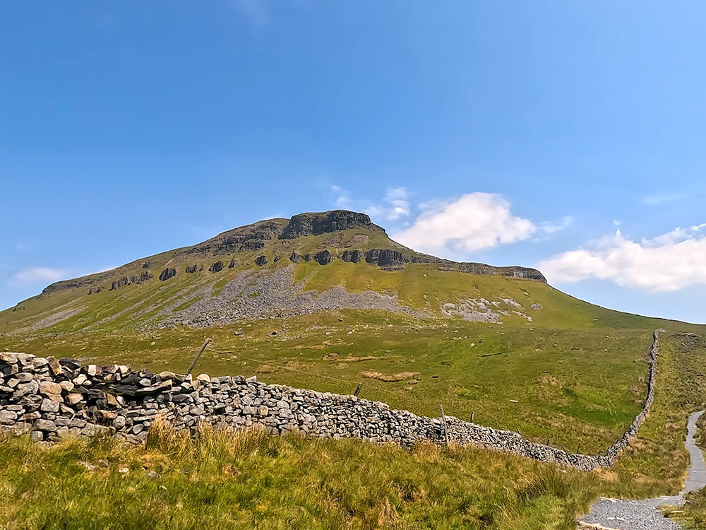
Continuing by the wall, pass through another next gate. Looking at Pen-y-ghent from here, you can see the two distinct climbs that need to be walked up to the summit.

Path heading towards short dip and rise up to meet the Pennine Way on the way to Pen-y-ghent
After a small dip and then a further rise in the path, pass through the next gate and turn left to join the Pennine Way. Directly across here is Fountains Fell, where many years ago the land was used by the Cistercian monks from Fountains Abbey 25 miles away, hence the name.

Pennine Way footpath sign heading up the steep steps towards Pen-y-ghent summit
From the gate, we follow the Pennine Way sign to start the first steep climb of the walk. The path initially heads up man-made steps before pulling round left in front of a large crag just before the top of this initial climb. Some hands may be needed for a short section here.
The path briefly flattens before starting up the steep steps of the second climb, at the top of which the flags are followed to the summit of Pen-y-ghent.

The steps up the second steep climb on the way to Pen-y-ghent summit

View looking back down the path just climbed up Pen-y-ghent
Pen-y-ghent itself is the lowest of the Yorkshire Three Peaks at 694 metres high.

View towards Ingleborough and Whernside from Pen-y-ghent summit

Fountains Fell from Pen-y-ghent summit
The onward route is through the gate stile in the wall behind the trig point, from where looking ahead you can see Whernside and Ribblehead Viaduct below it and then if you pan left is the flat top of Ingleborough's summit, and around to Pendle Hill on the far horizon and then around to Fountains Fell.
If you want a short stop on the summit of Pen-y-ghent, there are a couple of sheltered seats built into the wall.
Pass through the stile in the wall behind the trig point, where we then follow the Pennine Way Yorkshire Three Peaks footpath sign directly away from the wall. After a short distance, pick up some steps at the bottom of which, the path bends around to the right.

Steps leading down from Pen-y-ghent summit, with path to be followed stretching out ahead
About two hundred yards further on, the path bends sharply around to the left at a signpost and we follow this path.

Yorkshire 3 Peaks Walk signpost where the path bends around sharply left
The old Three Peaks route went on diagonally left here before the new path was built over Whitber Hill. The new path is much easier to walk on and to follow. It misses out on Black Dub and Red Moss, where I have everlasting memories of wading through thigh-high mud on my first few Yorkshire Three Peaks walks. So, if you read anywhere, the Three Peaks route has been changed, and it was quite a few years ago now this is the section that changed.
Follow the wide path downhill following the Yorkshire Three Peaks sign for High Birkwith via Whitber. Head on for about a mile passing through two gates to reach a 4-way signpost by a gate, through which leads down a walled lane back to Horton in Ribblesdale.

4-way signpost by the gate, the Yorkshire 3 Peaks Walk heads straight on over Whitber Hill
We ignore that lane and just keep straight on, on the initially gravelled path over Whitber Hill. After a while, the path heads down through a gap in the wall and over a wooden footbridge.
Walk along the path and then pass through either of the gate stiles and then follow the footpath down to the left, where a footpath sign is soon reached just short of a gate. We turn right here along the wide gravel track following the Yorkshire 3 Peaks footpath sign to High Birkwith.

Turning right to rejoin the Pennine Way
After about half a mile, pass through a gate and continue straight ahead along the gravel track. After about a further 350 metres, we turn left at a Yorkshire Three Peaks Footpath sign to High Birkwith through either of the two gates in a wall.

Heading along the Pennine Way path on the Yorkshire 3 Peaks Walk

Gate through which the Yorkshire 3 Peaks Walk leaves the Pennine Way to head towards High Birkwith
Just keep straight on the path by the side of the wall. Pass through the next gate stile and continue to where the footpath meets a track. Turn left here along the track and then further on pass through the wooden gate stile to the side of the metal gate.

Path joining the track at High Birkwith
Walk along the track to a T-junction, where you follow the track around to the left, following the Yorkshire Three Peaks Footpath sign. About 50 yards further on at another path and track junction, turn right to follow the Yorkshire Three Peaks Footpath sign to Nether Lodge one and a half miles.

Track junction where Yorkshire 3 Peaks Walk turns right
Walk along the track and then pass over the stone stile built into the wall. Walk away from the gate following the path where soon we meet a path that splits away left from the main track. Take this path, which is signed public footpath Ribblehead and keep on it to pass through another metal gate.

The Yorkshire 3 Peaks path heads left off the track
Walk along the track, and then at the next footpath sign, keep straight on following the Ribblehead two and a half miles of sign. Pass over a wooden footbridge and then continue to and pass through the gate just ahead, to continue along the gravelled path.

Wooden footbridge near Nether Lodge on the Yorkshire 3 Peaks Walk
At the next footpath sign, head right following the Yorkshire Three Peaks Ribblehead two-and-a-quarter-mile footpath sign along the wide gravel track. Pass over the wooden stile to the right of the gate and again continue straight on along the track, passing over a wooden footbridge and then through the next gate you meet.

Passing over the wooden footbridge
The buildings at Ingman Lodge are soon reached. Pass through a metal gate and then keep on the track and follow it until it climbs to meet the B6479 Horton to Ribblehead road.
Turn right along the road and follow it for approximately one mile until you reach the T-junction at Ribblehead. Up to the left here is the Station Inn and to the right are two laybys with additional parking.

Heading along the road towards Ribblehead and Whernside on the Yorkshire 3 Peaks Walk

Approaching the T-junction at Ribblehead, with the Ribblehead Viaduct and Whernside ahead
At the T-junction, cross over the road and then follow the path directly away from the road, following the Yorkshire Three Peaks Public Footpath sign.

Yorkshire Three Peaks footpath sign pointing towards the Ribblehead Viaduct
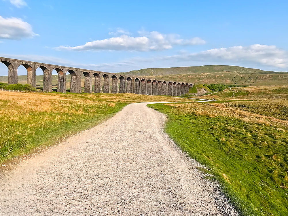
Continue along the gravel path towards the Ribblehead Viaduct, turning right when you meet another gravel track. Before reaching the viaduct, we head right off the wide track to head along the narrow path towards the footpath sign 'Whernside four and a half miles'.

Where the Yorkshire 3 Peaks path leaves the track just before the Ribblehead Viaduct

Looking across towards Ingleborough
Head straight on up some steps to pull in to the right of the railway. We walk parallel to the railway, passing through a gate and then on past the Blea Moor signal box.

Looking back over the gate towards Pen-y-ghent and Ingleborough

Blea Moor Signal Box
After that, keep on the path for about a kilometre until the path pulls in beside the aqueduct to cross over the Settle to Carlisle railway line. Cross over the aqueduct where, if you look over to your left, you'll see Simon Fell which heads up onto Ingleborough and to the right, you can see the railway tracks disappearing into Blea Moor Tunnel in Smithy Hill.

Ingleborough and the Settle to Carlisle railway line from the aqueduct
Over the aqueduct, pass through a wooden gate and keep straight on following the Bridleway sign for Dent Dale four miles. Head up some steps and then turn left through the gate, to start the steeper climb up the man-made steps. After about 500 metres, climb over the stile on the left, to follow the 'Whernside one and three-quarter mile' sign.

Yorhire 3 Peaks Walk footpath sign to Whernside by the stile
Head away from the stile, following the path, which becomes flagged underfoot for a section.

Flagged path heading towards Whernside summit
After the flags end, the path pulls in by the side of a wall, which is followed for about one kilometre, to the summit of Whernside. The Whernside summit trig point is just through the gap on the far side of the wall.

Path by the wall heading towards Whernside's summit with Ingleborough ahead

The trig point on Whernside
Whernside is the highest of the Yorkshire Three Peaks at 736 metres high and from the trig point you can see out to the sea at Morecambe Bay and then around to the Lakeland Fells. Looking further around you can see the Howgill Fells and then Pen-y-ghent, the Ribblehead Viaduct and Ingleborough.

View from the summit of Whernside of the Ribblehead Viaduct, Pen-y-ghent and Ingleborough
There are weather shelter seats on both sides of the wall at the summit. Head back through the gap in the wall from the trig point and turn right to walk along the path that keeps beside the wall. Pass through either of the next wooden gates you meet and then after a further half-mile, head down two short, slightly steeper sections.
At the bottom of the second one, the path heads off left directly away from the wall heading more steeply down the man-made steps, at the bottom of which, pass through a wooden gate and keep straight ahead towards Bruntscar below.

The Yorkshire 3 Peaks path heads away from the wall at the bottom of the steeper section

The path heading towards Bruntscar
Pass through another gate and continue heading down the path. Head down to and pass through the gate by the buildings and head down the track following it around to the right, following the sign for the 'Three Peaks Hill Inn one-and-a-quarter mile' sign.

Gate just before the buildings at Bruntscar

Looking back up towards Whernside from Bruntscar
Soon after turning right, turn down the road on the left, again following the 'Yorkshire Three Peaks Hill Inn one-and-a-quarter mile' sign.

The left turn down the road following the Yorkshire 3 Peaks footpath sign
Head down the road, passing over a series of cattle grids, after which the road then bends around to the right and starts to rise. Pass by the campsite at Philpin Farm on your right and then past a barn, which houses a café which is open at certain times of the year.

Passing over one of the cattle grids on the road

Passing by the barn at Philpin Farm
Pass over another cattle grid and keep on the road until you meet and turn left onto the B6255 Ingleton to Ribblehead road. Heading up the road, pass by the Old Hill Inn, where you soon reach a gate and a footpath sign just before the small building on the right.

The Old Hill Inn

The right turn off the road just before the building to follow the path towards Ingleborough
Turn right off the road here, passing through the gate following the 'Yorkshire Three Peaks public bridleway Great Duke' sign.
Head away from the wall along the wide gravel track, passing through two wooden gates in the direction of Ingleborough ahead. Pass through another gate and then just continue straight on through the limestone outcrops of Southerscales Scar.

Wide grassy path heading towards Ingleborough

The path as it passes Southerscales Scar
The large hole to the left of the path that you pass is the 'Braithwaite Wife Hole', a collapsed doline or shake hole in which there is a cave entrance. Keep on past that and a gate in a wall is soon reached.

The Yorkshire 3 Peaks path as it heads through the limestone outcrops on the way towards Ingleborough

The gate in the wall before the stepped and flagged section on the path towards Ingleborough
Pass through the gate and head away from the wall up the flagged path, until a steep climb is reached. Head up the steps here, the path zigzags for a short while to make the climb less steep. At the top of the climb, hands may be needed briefly.

The flagged path heading towards Ingleborough

The zigzag path heading up the steep climb on Ingleborough
As the path flattens, head on through the next gate and then start to climb the next steps. Towards the top of the steps, before reaching the summit plateau of Ingleborough, we reach a stone marker. This is a very important marker because after we have visited the summit of Ingleborough, we return to it as part of our route back to Horton in Ribblesdale.

Steps heading up towards Ingleborough's plateau summit

Stone waymarker, marking where the path splits on the way back down
Keep on past the stone marker up the steps and just before reaching the summit plateau itself, we pass to the right of a large boulder. Again, take note of this, as when you are coming back from the summit of Ingleborough, you need to spot this and spot the path that comes back down to the left of it.

The path passes by the right-hand side of the large boulder
Pass the cairn and head onto the summit plateau where there are a couple of cairns to the right. The path passes by the second one keeping more or less along the edge and then heads diagonally left across to the weather shelter and then on to the triangulation point about 100 metres further on, to reach the summit of Ingleborough.

The path past the cairns on Ingleborough's summit plateau
In bad visibility, you should take a compass bearing from the start of the summit plateau to the trig as this is the point where people are tired and more likely to make mistakes and this is where most people get lost on the top of Ingleborough. On a clear day, there's no issue with that because when you reach the second cairn, you can start to see the weather shelter up on the horizon and Ingleborough's trig point is just past the weather shelter.

Looking out towards the sea at Morecombe Bay and the faint outline of the Lakeland Fells from Ingleborough's trig point
Ingleborough at 724 metres is the second highest of the Yorkshire Three Peaks. From the summit you can see the Lakeland Fells to the north and as far away as the Snowdonia range to the south.

The view across to the Ribblehead Viaduct and Whernside

Looking towards the weather shelter, Whernside and the Howgills from Ingleborough's summit trig point
From Ingleborough's summit, we start the descent by heading back down the outward route, passing the weather shelter, picking up the edge and passing by the cairns we passed on the way up. Look for and head down to the left of the large boulder and head back down to the stone marker, where the path splits.

The path off Ingleborough's summit plateau passes by the left-hand side of the large boulder

Heading back down to the stone waymarker, the path back to Horton in Ribblesdale is the right-hand one
This time, instead of taking the left-hand path we walked up, we take the right-hand path that at the outset heads down some steps and passes by a small tarn on the left to down and across Simon Fell Breast.

The path passes by the small tarn as it heads out across Simon Fell Breast
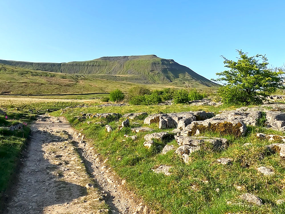
After about one mile from the stone marker, pass over a wall stile and keep ahead in the direction of Pen-y-ghent directly ahead.

The gate in the wall with Pen-y-ghent ahead on the horizon
After a while, the path heads over some boards and then past a disused shooting hut.

The path heads across the wooden boards with Pen-y-ghent ahead

The Yorkshire 3 Peaks path passing by the shooting hut
Keep on over a small stream and immediately pass through a wooden gate in a wall, next to which there is a signpost showing two-and-three-quarter miles to Horton in Ribblesdale. Walk on from the wall and then after about 50 yards where the path splits, take the left-hand path in the direction of Pen-y-ghent, following the yellow arrow on the wooden waymarker.

Take the left-hand path at the wooden waymarker
After a while, the path heads between a wall and a limestone pavement, at the end of which it passes through the next gate and then continues straight along the path.

The Yorkshire 3 Peaks path passing between the wall and the limestone pavement
After a further 400 metres, with Pen-y-ghent directly ahead in the distance, continue straight on at the fingerpost following the Horton in Ribblesdale two miles footpath sign.

The flagged path with Pen-y-ghent on the horizon

Keep staright ahead at the signpost
Pass through the next gate and again continue straight on. Upon reaching the next signpost again, keep straight on following the Yorkshire Three Peaks Horton in Ribblesdale one-mile footpath sign.

Another flagged section on the Yorkshire Three Peaks path with Pen-y-ghent just visible on the horizon

Continue straight on at the Yorkshire 3 Peaks footpath sign
The path then weaves its way through some exposed limestone, passes through a gap in a wall and bends around to the right following wooden waymarkers and small cairns.

The path passes through the gap in the wall and then bends around to the right
Upon reaching an information board just in front of the next wall, pass through the gate continuing on the path to reach another wall and again just head through the gate and continue ahead on the well-defined path.

The path heads down to the information board by the gate in the wall

Through this gate there is just one final field to cross before reaching Horton in Ribblesdale
Pass through the next gate and then across another field at the end of which is a gate that leads down into Horton in Ribblesdale train station. Head down to and carefully cross the train track, then pass through the gate opposite and head down the road until we meet the road at the bottom.

Carefully cross over the train tracks at Horton in Ribblesdale train station
Upon meeting the road, just continue straight ahead along the pavement, at the end of which follow it around to the right to pass over a wooden footbridge and back into Horton in Ribblesdale car park, where the walk started.

The wooden bridge just before the car park at Horton in Ribblesdale

The path back into the car park at Horton in Ribblesdale - the end of the walk!
Check out the reviews for this walk: