Written by: Andrew Forrest
Updated: July 2025
Over the years, we have been asked many questions about the Yorkshire 3 Peaks Walk and the Yorkshire 3 Peaks Challenge. Below, we have compiled the most frequently asked questions about these events and have divided over seventy questions into the various aspects of the Yorkshire 3 Peaks walk.
This page contains affiliate links. If you buy products or services via these links, we may earn a small commission at no cost to you. If you are thinking of buying, please use our links, as it helps support our website and YouTube channel.
The Yorkshire 3 Peaks are Pen-y-ghent, Whernside and Ingleborough.
The 24.6-mile circular walk, which takes in the mountaintop summits of Pen-y-ghent, Whernside and Ingleborough is known as the Yorkshire 3 Peaks Walk or the Yorkshire 3 Peaks Challenge and involves just over 1,600 metres of climbing.
The Yorkshire 3 Peaks are in the Yorkshire Dales.
Most people start the Yorkshire 3 Peaks walk from Horton in Ribblesdale.
Most people walking the Yorkshire Three Peaks start and end in Horton in Ribblesdale and walk anti-clockwise, so walk Pen-y-ghent first, Whernside, and Ingleborough.
There is no official starting point, and as it is a circular walk, you can start anywhere on the route and complete it in either an anti-clockwise or clockwise direction - the choice is yours!
April to early September is the best time of the year to do the Yorkshire 3 Peaks Walk or 3 Peaks Challenge. From April to early September, the days are longer than the nights, resulting in more than 12 hours of sunshine, and the weather is generally dryer and warmer.
You can take as long as you like to complete the Yorkshire Three Peaks walk, even walking them separately over three days, but the Yorkshire Three Peaks 'challenge' is to do the whole walk in under 12 hours. So, if you have more than 12 hours of potential daylight, this helps.
Many people set off early, just before the sunrise, to extend the daylight period and complete the walk. This is helped by the fact that the path out of Horton in Ribblesdale towards Pen-y-ghent is reasonably easy to follow, even in the dark with a headtorch.
The Yorkshire 3 Peaks Walk is a 24.6-mile walk from Horton in Ribblesdale in the Yorkshire Dales that passes over the summits of Pen-y-ghent (694 metres), Whernside (736 metres) and Ingleborough (724 metres) and includes a total ascent of 1,610 metres.
Most people walk the Yorkshire Three Peaks alone, with small groups of friends, or alongside colleagues from work or a club.
If you are unsure of the directions or want to raise money for your chosen charity, there are many organised charity Yorkshire 3 Peaks Walks that you could sign up for.
The Yorkshire 3 Peaks should not be undertaken lightly. It is a long walk of over 24 miles, and you climb three exposed mountains: Pen-y-ghent, Whernside and Ingleborough.
Everyone's perception of difficulty is different; if you are a fit, experienced walker, you may find the walk tiring but not too difficult.
If you are not very fit, you will find the walk challenging, so we always recommend training to get fit for the walk. Ideally, you can train by doing the hills individually first to familiarise yourself with them and the route. More accidents and poor decisions occur when people are tired, so you need to be physically fit enough to complete the walk.
Although the paths are well marked and signed, navigation can become difficult if the weather is poor, especially on the summit of Ingleborough, so it is advisable to know how to use a map and compass.
In my opinion, Whernside, although it is the highest, always seems to be the easiest to climb, especially from Ribblehead, as the path rises gradually. There is one short, steep descent.
Pen-y-ghent has two short, steep sections where hands may briefly be needed - some people would call it a brief scramble, but it lasts only for a few metres.
Ingleborough again has one steep section where hands may be briefly needed. Many people find Ingleborough the hardest part of the Yorkshire 3 Peaks walk, but that is probably because it comes towards the end when your legs are already tired.
The weather has a significant impact on the three hills; climbing them in snow and ice is far more challenging than walking them on a still summer's day.
Overall, there are 1,610 metres of elevation gain or ascent on The Yorkshire 3 Peaks Walk.
The highest of the Yorkshire 3 Peaks is Whernside at 736 metres, followed by Ingleborough at 724 metres, with Pen-y-ghent being the lowest at 694 metres.
Whernside is the highest of the Yorkshire 3 Peaks at 736 metres high.
There are toilets located at the start and finish of the walk in the pay-and-display car park in Horton in Ribblesdale.
Yes, all 3 of the Yorkshire 3 Peaks are mountains.
In the U.K., a mountain is generally any peak above 2,000 feet or 610 metres.
Whernside is 736 metres, Ingleborough is 724 metres, and Pen-y-ghent is 694 metres, all classified as mountains.
The Yorkshire 3 Peaks Fell race is run yearly, usually in the last week of April, over the Yorkshire 3 Peaks. The height climbed is the same as the Yorkshire 3 Peaks walk, but the route is slightly different and slightly shorter.
The Yorkshire 3 Peaks fell race was first run in 1954 with six starters, three of whom finished. The race now attracts between 800 and 1,000 runners, with the event held annually on the last Saturday in April.
The race is now part of the World Mountain Ranking and a UTBM index race.
Andy Peace set the men's record for the current route at 2 hours and 46 minutes, and the women's record was set by Victoria Wilkinson at 3 hours and 9 minutes. Jeff Norman held the old course record at 2 hours 29 minutes, but that was around a shorter course.
The Yorkshire 3 Peaks Viaduct is the Ribblehead Viaduct, which is passed on the Yorkshire 3 Peaks walk at Ribblehead on the route between Pen-y-ghent and Whernside.
You can walk on any of the footpaths making up the Yorkshire Three Peaks walk for free.
Yes, there is a train station in Horton in Ribblesdale, situated on the renowned Settle to Carlisle railway line.
Unfortunately, the Pen-y-ghent Café, sometimes known as the Yorkshire 3 Peaks Café, closed in 2018.
Unfortunately, the Pen-y-ghent Café that ran the clocking-in and clocking-out machine for the Yorkshire 3 Peaks walk closed in 2018.
Unfortunately, the Pen-y-ghent Café that ran the 3 Peaks of Yorkshire Club for those who had completed the Yorkshire 3 Peaks walk closed in 2018.
Yes, you can do the Yorkshire Three Peaks on your own. You do not have to do it in a group or for an organised charity event.
Walking with others for the company is always enjoyable, but if you are doing it on your own, always make sure someone knows you are doing it, knows your route and when you are expected to return. Check out our safety tips for walking.
The choice is yours - you can walk it clockwise or anti-clockwise. Being a circular route, you can start the walk from anywhere along the route.
I prefer the anti-clockwise route, starting with Pen-y-ghent from Horton in Ribblesdale. The majority of people who walk it, choose this route.
Most people start the walk in Horton in Ribblesdale.
As there is no official starting point, and it is a circular walk, you can start the walk from another point, such as Ribblehead or Chapel le Dale, but Horton in Ribblesdale is by far the most used starting point for the Yorkshire 3 Peaks.
If you are starting the Yorkshire 3 Peaks walk in Horton in Ribblesdale, the postcode for the car park is BD24 0HG.
If you are starting the Yorkshire 3 Peaks walk in Horton in Ribblesdale, the what3words for the car park is tonality.curl.routs.
If you are starting the Yorkshire 3 Peaks from Horton in Ribblesdale, there is a pay-and-display car park. There is additional paid parking next to the Golden Lion. On some days, an additional field between the car park and the train station opens for parking. Charities often use this field. There is some roadside parking in Horton in Ribblesdale, but please park sensibly and keep noise to an absolute minimum on early morning starts.
If you start from Ribblehead, there are two laybys to park in. In summer and at weekends, they can get busy.
The time it takes to complete the Yorkshire 3 Peaks walk depends on your fitness level, the fitness level of those you are walking with, and how much you have prepared and trained for the walk.
The Yorkshire 3 Peaks 'challenge' is to do the walk in under 12 hours. Most reasonably fit, well-prepared walkers take, on average, between 9 and 11 hours to do the walk.
You should get a feel for the speed as you walk and climb on your practice walks. Remember, however, that you will probably start to slow down towards the end of the walk.
The Yorkshire 3 Peaks is 24.6 miles long.
The Yorkshire 3 Peaks Walk is 24.6 miles (39.4 km) long.
This depends upon your level of fitness and training and the weather on the day you walk the Yorkshire 3 Peaks.
The Yorkshire 3 Peaks Walk is 24.6 miles and includes 1,610 m of elevation gain, so many people tire towards the end if they have not done enough preparation.
The Yorkshire 3 Peaks 'challenge' is to complete the walk in under 12 hours.
Most reasonably fit walkers who have done some training usually take between 9 and 11.5 hours to do the walk.
There is a Yorkshire 3 Peaks fell race each April, where the country's top fell runners run the Yorkshire 3 Peaks. Their route is slightly different and a little shorter, but the current record is an astonishing 2 hours 46 minutes!!
The Yorkshire 3 Peaks Fell Race takes place on the last Saturday in April each year.
On average, reasonably fit walkers who have properly prepared complete the walk in between 9 and 11.5 hours.
Yorkshire 3 Peaks route timings are when you need to be at specific points of the walk to achieve your overall target time.
The current Yorkshire 3 Peaks record time is an amazing 2 hours 46 minutes!! England International Andy Peace set this.
The women's record, also equally impressive, is 3 hours 9 minutes set by Victoria Wilkinson.
There is a Yorkshire 3 Peaks fell race each April, where the country's and some of the world's top fell runners run the Yorkshire 3 Peaks. The climb remains the same, but the route itself is slightly different and a little shorter, which is when these records were set.
People's stride lengths differ, but on average, people take around 2,000 steps per mile. So, with the walk being 24.6 miles long, that is approximately 49,000 steps.
They are not always 100% accurate, but the last time I walked it, using my Garmin watch, I clocked approximately 44,000 steps. I am slightly taller than average, so my stride length is probably slightly longer than average.
The Yorkshire 3 Peaks Route is a 24.6-mile circular walk that takes in the summits of Pen-y-ghent, Whernside and Ingleborough. The Yorkshire 3 Peaks Walk, or the Yorkshire 3 Peaks Challenge, involves just over 1,600 metres of climbing.
The Yorkshire 3 Peaks Route is shown on our Yorkshire 3 Peaks Route map.
The directions for the entire Yorkshire 3 Peaks Route are shown in our Yorkshire 3 Peaks Walk video.
Brief Yorkshire 3 Peaks route directions are outlined in our Yorkshire 3 Peaks Walk description.
A free GPX download of the Yorkshire 3 Peaks Walk is available.
The Yorkshire 3 Peaks Route that featured on this website, including the Yorkshire 3 Peaks Walks Video, Yorkshire 3 Peaks Route Map or Yorkshire 3 Peaks Walk Description, follows the 'new' Yorkshire 3 Peaks route.
The route has always been the same, but around 2012, one small section of the path was changed to avoid a few notoriously boggy areas, ensuring that people walked on the main path.
Previously, when descending Pen-y-ghent, near where the path bends sharply to the left and descends steeper, the 'old' path headed in a straight line from here to meet up with the Pennine Way but passed through Todber Moss, Black Dub Moss and Red Moss, which from personal experience were always very wet and very boggy!
The 'new' path takes you down the usual, wider, gravelled path off Pen-y-ghent to the top of Horton Scar Lane and then on the 'new' gravelled path over Whitber Hill to join up with the Pennine Way. The overall path is slightly longer but much dryer and easier to walk on. Some people still refer to this as 'new', but it was around 2012 that this one small section of the walk underwent a change.
The recommended Yorkshire 3 Peaks route is the one outlined in our Yorkshire 3 Peaks Video, Yorkshire 3 Peaks Route Map and our Yorkshire 3 Peaks Walk description. The route follows the Yorkshire 3 Peaks footpath signs.
There is no official starting point, so since the walk is circular, you can start at any point and walk it in either a clockwise or counter-clockwise direction.
Most people start the walk in Horton in Ribblesdale and walk anti-clockwise, taking Pen-y-ghent, Whernside and Ingleborough in that order.
The best route for the Yorkshire 3 Peaks is the route we have outlined in our Yorkshire 3 Peaks walk video, our Yorkshire 3 Peaks route map, and our Yorkshire 3 Peaks walk description.
This route is well-signed and follows good, well-maintained paths and short road sections. There is only one section across the summit of Ingleborough where the path is not well-defined.
If you have a phone or GPS device you can download the GPX route for the Yorkshire 3 Peaks Walk for free from Walks4all.com, allowing you to view the route on your device.
Many people simply download the GPX route file onto their smartphone and view it in a mapping app.
The mapping app I currently use is the Ordnance Survey mapping app, and for just £2.99/month, I get access to all their 1:25,000 maps in the UK along with many other maps and features, including the ability to print maps.
Ordnance Survey Mapping App
Use on any device and make it easy to explore the great outdoors for just the price of a coffee a month. Premium allows full UK access to all OS Explorer and Landranger mapping, along with the ability to import and export routes, save maps offline, aerial 3D, and print A3/A4 maps.
Explore further and sign up for the
OS Mapping App.
If you already have the Ordnance Survey mapping app, rather than downloading the Yorkshire 3 Peaks walk route GPX file, look at Horton in Ribblesdale on the map, choose 'Find Routes' from the menu, click on 'walk/hike', and drag the length setting to (say) 32km so it only shows the longer walks from Horton in Ribblesdale.
Click 'Find Routes'. It will return you to the map and show a number in a circle. This is the number of walks on the OS mapping app that meet those criteria.
In that list, you will see a walk called 'Walks4all: Yorkshire Three Peaks Walk'. Simply click on that, and you will have the Yorkshire 3 Peaks Walk route shown on the map on your phone. There are options to download offline, which is advisable, so you'll have access to them even if you have no signal while out on the walk. Then, click on 'Start Route', and you're off!
The Walks4all 3 Peaks Walk route map is shown on the Ordnance Survey mapping app because we (Walks4all) are a recommended Route Partner to the Ordnance Survey. All our walks on the Walks4all.com website can be found on the Ordnance Survey mapping app.
A top tip is to always take a power bank with you. Mobile phones and GPS devices consume more power when using GPS, and taking numerous photographs along the way can cause your battery to run low or completely drain.
In case I have no power, I also always ensure I have a paper map of the area I'm walking in. If you have the mapping app, you can print the relevant map areas and take them with you or take the OS map that includes the walk.
The Ordnance Survey map that includes the Yorkshire 3 Peaks walk is the Ordnance Survey - Explorer OL2 (Yorkshire Dales - Southern & Western Area) map.
We have provided the Yorkshire 3 Peaks map on our Yorkshire 3 Peaks Walk description page.
This Yorkshire 3 Peaks route map shows the route around the Yorkshire 3 Peaks Walk starting from Horton in Ribblesdale.
The Ordnance Survey map that includes the Yorkshire 3 Peaks walk is the Ordnance Survey - Explorer OL2 (Yorkshire Dales - Southern & Western Area) map.
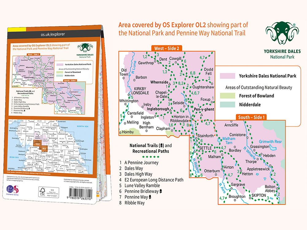
We have included the Yorkshire 3 Peaks Route map on our Yorkshire 3 Peaks walk description page. If you have a mapping app, such as Ordnance Survey, you can access our Yorkshire 3 Peaks Walk route map there or download our GPX route map file from Walks4all.com to your own mapping app.
These paid-for mapping apps generally allow you to print or save the route map as a PDF.
While you may be able to find the route on Google Maps, it is unsuitable for navigating the walk. You should either take the Ordnance Survey detailed map of the area, which shows all the footpaths, or a mapping app with the same 1:25,000 maps. Ideally, a paper map should always be taken, as that can never run out of power!
You must be equipped with the correct clothing and equipment to undertake the Yorkshire 3 Peaks Walk. We have put together a kit list so you know what you take and wear.
You will burn quite a lot of calories whilst walking the Yorkshire 3 Peaks or doing the Yorkshire 3 Peaks Challenge. Therefore, you need to continually replenish your body's fuel.
Most people do this by eating little and often throughout the day. Some people prefer solid food, while others opt for energy drinks, gels, or a combination of both. What you eat depends on your preference, and how much you eat is a function of your body weight (heavier people generally burn more calories) and what you can comfortably stomach.
On your training walks, experiment as to what works best for you. We have included some ideas in our kit list.
You will need fluid to get you around the Yorkshire 3 Peaks or whilst doing the Yorkshire 3 Peaks Challenge. It is best to drink little and often.
Some people like water and some prefer flavoured liquids or adding energy powders to their water. What you drink is largely a matter of personal preference, and how much you drink depends on your body type, your general level of sweating, and the temperature of the day. Do not underestimate how much you need, especially on a hot day. Remember that water is relatively heavy; 1 litre weighs approximately 1 kilogram.
On your training walks, experiment with what works best for you and determine how much water you will need. There are sometimes places where you can get additional drinks on the way around, as we've set out in our 3 Peaks Logistics page, but you cannot always rely on them as they may not be open. If you have more than one vehicle, you could always leave one car at Ribblehead and pick up additional water as you pass.
If you are new to walking, you need to build up your distance gradually over several months. You also need to incorporate some climbing into your training. If possible, walking the Yorkshire 3 Peaks individually as part of your training can be beneficial, as it will also familiarise you with the route and the hills. For a more detailed look at training for the Yorkshire 3 Peaks, check out our Yorkshire 3 Peaks Training Guide.
Although there is no specific official plan, we have outlined how to train for walking the Yorkshire 3 Peaks in our Yorkshire 3 Peaks training guide.
We would not recommend walking the Yorkshire 3 Peaks without proper training and preparation. People tend to make more mistakes when they are tired, often resulting in slips, trips, or poor navigation decisions.
The Yorkshire 3 Peaks should not be undertaken lightly. It is a long walk of over 24 miles, and you climb 1,610 metres over three exposed mountains (Pen-y-ghent, Whernside and Ingleborough). You also need to have the correct kit to complete the walk, ensuring your safety and that of others in your walking party is not compromised. Additionally, at least one member of your walking party should be able to navigate, and you all should be familiar with the route.
You will enjoy the 3 Peaks walk much more if you train and prepare first to be physically fit enough to do the walk.
The Yorkshire 3 Peaks Route is a 24.6-mile circular walk that takes in the summits of Pen-y-ghent, Whernside and Ingleborough. It is known as the Yorkshire 3 Peaks Walk and involves approximately 1,600 metres of climbing.
The Yorkshire 3 Peaks Challenge is essentially the same as the Yorkshire 3 Peaks walk, but with the goal of completing the walk in under 12 hours.
The Yorkshire 3 Peaks Route/Yorkshire 3 Peaks Challenge Route is shown on our Yorkshire 3 Peaks Route map.
The Yorkshire 3 Peaks Challenge is 24.6 miles long, with the 'challenge' part being that you walk it in under 12 hours.
We have provided the Yorkshire 3 Peaks Challenge map on our Yorkshire 3 Peaks Walk description page.
This Yorkshire 3 Peaks Challenge route map shows the route around the Yorkshire 3 Peaks Walk starting from Horton in Ribblesdale. This is precisely the same as the Yorkshire 3 Peaks map, with the 'challenge' part being that you need to complete the walk in 12 hours.
The Yorkshire 3 Peaks Walk is a 24.6-mile long walk from Horton in Ribblesdale in the Yorkshire Dales that passes over the summits of Pen-y-ghent (694 metres), Whernside (736 metres) and Ingleborough (724 metres) and includes a total ascent of 1,610 metres.
The Yorkshire 3 Peaks Challenge involves completing this walk within 12 hours.
So, the Yorkshire 3 Peaks Challenge 2026 is simply to complete this walk in under 12 hours in 2026.
You can do that on your own, with friends, work colleagues, an organised group, or a chosen charity.
If you want to raise money for your chosen charity, there are many organised charity Yorkshire 3 Peaks Walks that you could sign up for.
Although there is no specific official plan, we have outlined how to train for the Yorkshire 3 Peaks Challenge in our Yorkshire 3 Peaks training guide.
This guide outlines the training regimen for the Yorkshire 3 Peaks Walk and provides instructions on how to complete it in under 12 hours.
If you want to know what to pack for the Yorkshire 3 Peaks walk, check out our Yorkshire 3 Peaks Walk kit list.
No, you do not have to do the Yorkshire 3 Peaks walk for charity.
Yes, we have included the Yorkshire 3 Peaks walk route map in the Yorkshire 3 Peaks walk description.
The Yorkshire 3 Peaks walk route map is the same one used for all Yorkshire Three Peaks walks, including the charity ones. The Yorkshire 3 Peaks Charity walk route map takes in Pen-y-ghent, Whernside and Ingleborough, joining them together in a circular route from Horton in Ribblesdale.
If you have a phone or GPS device, you can download the GPX route for the Yorkshire 3 Peaks Walk for free, allowing you to view the route on your device.
The Yorkshire Three Peaks Challenge for Charity is walking the 24.6 miles Yorkshire 3 Peaks walk, starting from Horton in Ribblesdale in the Yorkshire Dales and climbing the 1,610 metres of ascent needed to pass over Pen-y-ghent, Whernside and Ingleborough within 12 hours for your chosen charity.
The route of the Yorkshire 3 Peaks walk is always the same - some people just use different names for it if they are trying to do it in under 12 hours (The Yorkshire Three Peaks Challenge) or doing it in under 12 hours for charity (The Yorkshire 3 Peaks Charity Challenge).
The Yorkshire 3 Peaks charity walk route in the Yorkshire Dales, as shown in the Yorkshire 3 Peaks walk description, is the walk that goes over Pen-y-ghent, Whernside and Ingleborough, joining them together in a circular route from Horton in Ribblesdale that is 24.6 miles long and includes over 1,600 metres of climbing.
If you have a phone or GPS device, you can download the GPX route for the Yorkshire 3 Peaks Charity Walk route for free.
The GPX file can be used on mapping apps such as the Ordnance Survey mapping app, from which besides having the app on your phone, you can also print a paper copy of the Yorkshire 3 Peaks charity walk route.
The Pen-y-ghent Café in Horton in Ribblesdale, which used to double as the Tourist Information Centre, provided a clocking-in and out machine and safety service. When you completed the walk, you could apply to join the '3 Peaks Club' and obtain various certificates, ties, badges/medals and other merchandise.
Unfortunately, the café and Tourist Information Centre closed in 2018.
The Yorkshire Dales website has a Yorkshire 3 Peaks certificate you can download, print and complete. This is the best option if you want a certificate of your own for free.
If you are doing the walk for charity or an organised group, they often have their own tailored certificates.
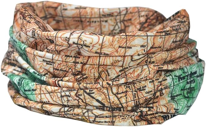
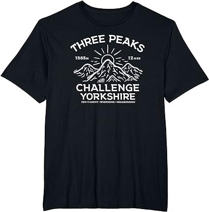
Whilst the 3 Peaks Club run by the Pen-y-ghent Café may be a thing of the past, so no more 'official' Yorkshire 3 Peaks Club 'ties' or 'sew-on patches', we've come across a few items of Yorkshire 3 Peaks merchandise that you may wish to purchase to celebrate completing the walk.
A hypoallergenic, microfibre neck warmer / snood featuring the Yorkshire 3 Peaks - almost a base layer for your head and neck!
 |
 |
You've done the walk, now get the T-shirt to show everyone what you've done! Available in 6 colours.

|
|
|
|
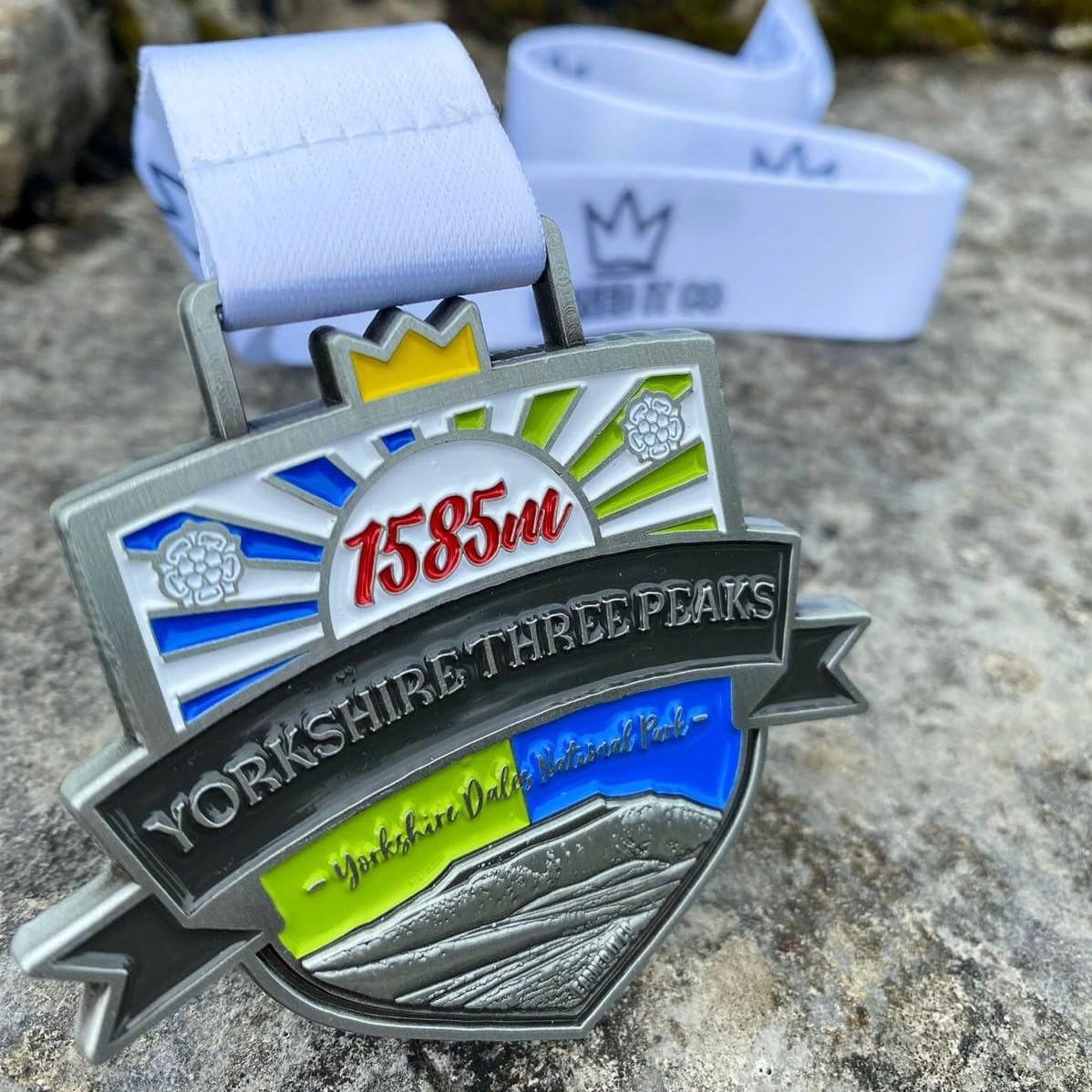
If T-shirts aren't your thing... how about a medal to say 'I've done the walk'?
|
|